
Geographic Region: AUSTRALIA-SA
Feature: ADELAIDE,ROADS,DOCKS,AGR
|
Geographic Region: AUSTRALIA-SA Feature: ADELAIDE,ROADS,DOCKS,AGR |
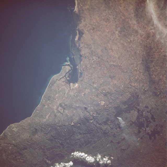 |
| STS077-741-096 Adelaide, South Australia, Australia May 1996 Visible in this northeast-looking, low-oblique photograph is Adelaide--the capital and chief port of the state of South Australia and the first municipality in Australia to be incorporated. The city, whose population is approximately 1 million, sits at the mouth of the Torrens River on the Gulf of Saint Vincent, an inlet of the Indian Ocean 90 miles (145 kilometers) long and 45 miles (72 kilometers) wide from which salt is obtained by solar evaporation. Adelaide has automotive, farm implement, furniture, and textile industries. Grain, wool, dairy products, and fruit are chief exports. The rugged Mount Lofty Range, in which a fire and its smoke plume are discernible, lies south and east of the city (bottom of the photograph). |
| Images: | All Available Images Low-Resolution 105k |
|
| Mission: | STS077 |
|
| Roll - Frame: | 741 - 96 |
|
| Geographical Name: | AUSTRALIA-SA |
|
| Features: | ADELAIDE,ROADS,DOCKS,AGR |
|
| Center Lat x Lon: | 35S x 138.5E |
|
| Film Exposure: | N | N=Normal exposure, U=Under exposed, O=Over exposed, F=out of Focus |
| Percentage of Cloud Cover-CLDP: | 5 |
|
| Camera:: | HB |
|
| Camera Tilt: | 27 | LO=Low Oblique, HO=High Oblique, NV=Near Vertical |
| Camera Focal Length: | 250 |
|
| Nadir to Photo Center Direction: | N | The direction from the nadir to the center point, N=North, S=South, E=East, W=West |
| Stereo?: | Y | Y=Yes there is an adjacent picture of the same area, N=No there isn't |
| Orbit Number: | 125 |
|
| Date: | 19960527 | YYYYMMDD |
| Time: | 052953 | GMT HHMMSS |
| Nadir Lat: | 36.2S |
Latitude of suborbital point of spacecraft |
| Nadir Lon: | 138.1E |
Longitude of suborbital point of spacecraft |
| Sun Azimuth: | 319 | Clockwise angle in degrees from north to the sun measured at the nadir point |
| Space Craft Altitude: | 152 | nautical miles |
| Sun Elevation: | 21 | Angle in degrees between the horizon and the sun, measured at the nadir point |
| Land Views: | HILL, COAST |
|
| Water Views: | GULF |
|
| Atmosphere Views: | PLUME |
|
| Man Made Views: | URBAN AREA, AGRICULTURE |
|
| City Views: | ADELAIDE |
|
Photo is not associated with any sequences | ||
| NASA Home Page |
JSC Home Page |
JSC Digital Image Collection |
Earth Science & Remote Sensing |
|
This service is provided by the International Space Station program and the JSC Earth Science & Remote Sensing Unit, ARES Division, Exploration Integration Science Directorate.

|