
Geographic Region: EGYPT
Feature: NILE RIVER & DELTA, AGR.
|
Geographic Region: EGYPT Feature: NILE RIVER & DELTA, AGR. |
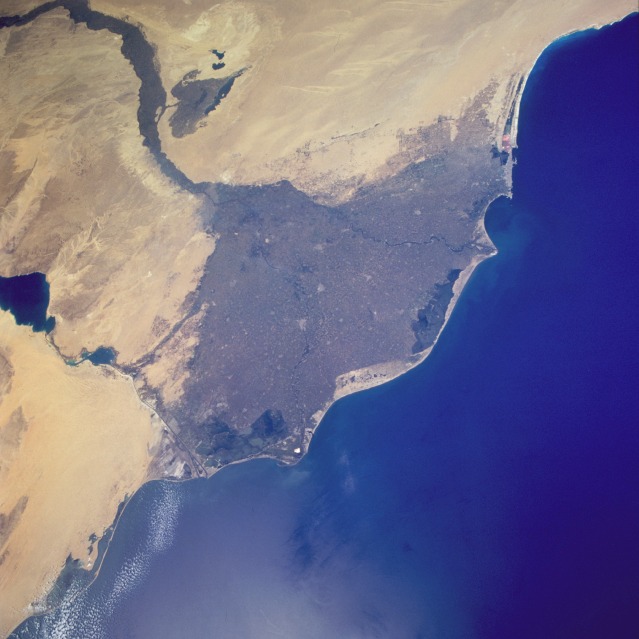 |
| STS077-718-054 Nile River Delta, Egypt May 1996 The great Nile River Delta, seen in this south-southeast-looking, low-oblique photograph, is the prototype for all other deltas. Early geographers, reminded of the Greek letter delta when noting its roughly triangular shape, named it accordingly. The delta stretches approximately 100 miles (160 kilometers) north and south and 150 miles (240 kilometers) west and east. Beginning at Cairo, the delta disperses the Nile's water into the Mediterranean Sea through a fan-shaped network of shallow channels. Two barely discernible rivers, the Rosetta (Rashîd) to the west and the Damietta (Dumyât) to the east, each approximately 150 miles (240 kilometers) long, carry most of the water to the sea. The thick layers of silt carried downstream for thousands of years provide the Nile Delta with the most fertile soil in Africa. With the completion of the Aswan High Dam in 1971, the delta's normal evolution has been disrupted--sediment that formerly reached the lower river valley is now halted by Lake Nasser, resulting in salt water from the Mediterranean seeping into parts of the delta; nutrients formerly carried downstream have been reduced, thereby depleting the population of some fish species in the Nile and the eastern Mediterranean. Visible are the Suez Canal and the Nile River Valley, east and south, respectively, of the delta. |
| Images: | All Available Images Low-Resolution 88k |
|
| Mission: | STS077 |
|
| Roll - Frame: | 718 - 54 |
|
| Geographical Name: | EGYPT |
|
| Features: | NILE RIVER & DELTA, AGR. |
|
| Center Lat x Lon: | 31.0N x 31.0E |
|
| Film Exposure: | N | N=Normal exposure, U=Under exposed, O=Over exposed, F=out of Focus |
| Percentage of Cloud Cover-CLDP: | 5 |
|
| Camera:: | HB |
|
| Camera Tilt: | 32 | LO=Low Oblique, HO=High Oblique, NV=Near Vertical |
| Camera Focal Length: | 40 |
|
| Nadir to Photo Center Direction: | SW | The direction from the nadir to the center point, N=North, S=South, E=East, W=West |
| Stereo?: | Y | Y=Yes there is an adjacent picture of the same area, N=No there isn't |
| Orbit Number: | 31 |
|
| Date: | 19960521 | YYYYMMDD |
| Time: | 075509 | GMT HHMMSS |
| Nadir Lat: | 32.4N |
Latitude of suborbital point of spacecraft |
| Nadir Lon: | 31.8E |
Longitude of suborbital point of spacecraft |
| Sun Azimuth: | 108 | Clockwise angle in degrees from north to the sun measured at the nadir point |
| Space Craft Altitude: | 153 | nautical miles |
| Sun Elevation: | 62 | Angle in degrees between the horizon and the sun, measured at the nadir point |
| Land Views: | COAST, DESERT |
|
| Water Views: | RIVER, DELTA, CANAL |
|
| Atmosphere Views: | |
|
| Man Made Views: | AGRICULTURE |
|
| City Views: | |
|
Photo is not associated with any sequences | ||
| NASA Home Page |
JSC Home Page |
JSC Digital Image Collection |
Earth Science & Remote Sensing |
|
This service is provided by the International Space Station program and the JSC Earth Science & Remote Sensing Unit, ARES Division, Exploration Integration Science Directorate.

|