
Geographic Region: CYPRUS
Feature: ENTIRE I., TURKISH COAST
|
Geographic Region: CYPRUS Feature: ENTIRE I., TURKISH COAST |
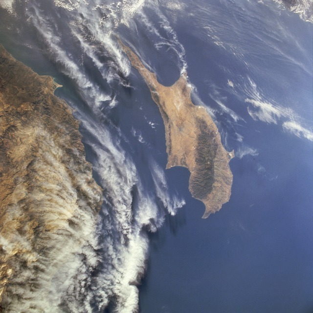 |
| STS077-717-018 Cyprus May 1996 Cyprus, covering 3578 square miles (9267 square kilometers) in the eastern Mediterranean Sea 40 miles (60 kilometers) south of Turkey, is apparent in this south-looking, low-oblique photograph. The island has an irregular shape, a number of wide bays and prominent capes, and two east-west-oriented mountain ranges--the higher Troödos Mountains in the southwest and the lower Kyrenia Mountains in the north-northeast. Between the mountain ranges lies a wide plain, the island's chief agricultural area that produces grapes (used for wine making), cereals, olives, tobacco, citrus fruits, and cotton. Sheep and goat raising, silkworm cultivation, and fishing are important livelihoods on the island. Mineral resources include copper, gypsum, chrome, and asbestos. Cape Bagase is the small protrusion into the Mediterranean Sea from the Turkish mainland (lower left). Clouds cover most of the Taurus Mountains of Turkey (bottom third of the photograph). |
| Images: | All Available Images Low-Resolution 112k |
|
| Mission: | STS077 |
|
| Roll - Frame: | 717 - 18 |
|
| Geographical Name: | CYPRUS |
|
| Features: | ENTIRE I., TURKISH COAST |
|
| Center Lat x Lon: | 35.5N x 33.0E |
|
| Film Exposure: | N | N=Normal exposure, U=Under exposed, O=Over exposed, F=out of Focus |
| Percentage of Cloud Cover-CLDP: | 30 |
|
| Camera:: | HB |
|
| Camera Tilt: | 24 | LO=Low Oblique, HO=High Oblique, NV=Near Vertical |
| Camera Focal Length: | 40 |
|
| Nadir to Photo Center Direction: | S | The direction from the nadir to the center point, N=North, S=South, E=East, W=West |
| Stereo?: | N | Y=Yes there is an adjacent picture of the same area, N=No there isn't |
| Orbit Number: | 93 |
|
| Date: | 19960525 | YYYYMMDD |
| Time: | 045414 | GMT HHMMSS |
| Nadir Lat: | 36.6N |
Latitude of suborbital point of spacecraft |
| Nadir Lon: | 32.8E |
Longitude of suborbital point of spacecraft |
| Sun Azimuth: | 82 | Clockwise angle in degrees from north to the sun measured at the nadir point |
| Space Craft Altitude: | 151 | nautical miles |
| Sun Elevation: | 26 | Angle in degrees between the horizon and the sun, measured at the nadir point |
| Land Views: | ISLAND, COAST, MOUNTAIN |
|
| Water Views: | SEA |
|
| Atmosphere Views: | |
|
| Man Made Views: | |
|
| City Views: | |
|
Photo is not associated with any sequences | ||
| NASA Home Page |
JSC Home Page |
JSC Digital Image Collection |
Earth Science & Remote Sensing |
|
This service is provided by the International Space Station program and the JSC Earth Science & Remote Sensing Unit, ARES Division, Exploration Integration Science Directorate.

|