
Geographic Region: MEXICO
Feature: COZUMEL I., COAST, ROADS
|
Geographic Region: MEXICO Feature: COZUMEL I., COAST, ROADS |
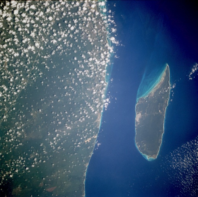 |
| STS077-704-012 Cozumel, Mexico May 1996 The partly cloudy east coast of the Yucatán Peninsula and the resort island of Cozumel are apparent in this southwest-looking, low-oblique photograph. Cozumel Island, a popular tourist and resort area 24 miles (39 kilometers) long and 7 miles (11 kilometers) wide, is noted for its beautiful beaches and spectacular coral reefs. Point Molas is visible at the northeast tip of the island. Expansion of roads and clearings for homes, golf courses, and other recreational features are discernible. Cozumel and the Yucatán Peninsula are susceptible to hurricanes from July through mid-October. Hurricane Gilbert in 1987 was the last major hurricane to hit the area. |
| Images: | All Available Images Low-Resolution 129k |
|
| Mission: | STS077 |
|
| Roll - Frame: | 704 - 12 |
|
| Geographical Name: | MEXICO |
|
| Features: | COZUMEL I., COAST, ROADS |
|
| Center Lat x Lon: | 20.5N x 87W |
|
| Film Exposure: | O | N=Normal exposure, U=Under exposed, O=Over exposed, F=out of Focus |
| Percentage of Cloud Cover-CLDP: | 15 |
|
| Camera:: | HB |
|
| Camera Tilt: | 42 | LO=Low Oblique, HO=High Oblique, NV=Near Vertical |
| Camera Focal Length: | 250 |
|
| Nadir to Photo Center Direction: | S | The direction from the nadir to the center point, N=North, S=South, E=East, W=West |
| Stereo?: | N | Y=Yes there is an adjacent picture of the same area, N=No there isn't |
| Orbit Number: | 37 |
|
| Date: | 19960521 | YYYYMMDD |
| Time: | 170027 | GMT HHMMSS |
| Nadir Lat: | 22.8N |
Latitude of suborbital point of spacecraft |
| Nadir Lon: | 87.3W |
Longitude of suborbital point of spacecraft |
| Sun Azimuth: | 100 | Clockwise angle in degrees from north to the sun measured at the nadir point |
| Space Craft Altitude: | 153 | nautical miles |
| Sun Elevation: | 79 | Angle in degrees between the horizon and the sun, measured at the nadir point |
| Land Views: | ISLAND, FOREST, COAST |
|
| Water Views: | |
|
| Atmosphere Views: | |
|
| Man Made Views: | |
|
| City Views: | |
|
Photo is not associated with any sequences | ||
| NASA Home Page |
JSC Home Page |
JSC Digital Image Collection |
Earth Science & Remote Sensing |
|
This service is provided by the International Space Station program and the JSC Earth Science & Remote Sensing Unit, ARES Division, Exploration Integration Science Directorate.

|