Geographic Region: NEPAL
Feature: TIBET, MT. EVEREST,INDIA
|
Geographic Region: NEPAL Feature: TIBET, MT. EVEREST,INDIA |
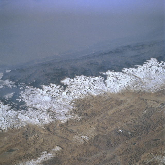 |
| STS076-727-080 Himalaya Mountains, Nepal March 1996 The Himalaya Mountains provide a formidable physical barrier between the hazy environmental conditions of north central India (top) and Nepal (middle), and the clear atmosphere of the Tibetan Plateau (lower third of image). Elevation disparities in this region of the world are tremendous. For example the elevations on the Gangetic Plain in India averages about 300 feet (92 meters) above sea level, the foothills (dark-looking features that run laterally across the image) in Nepal average about 2500 feet (762 meters), and finally the snow capped Himalayas average around 24000 feet (7315 meters). Mt. Everest, highest mountain peak in the world at 29028 feet (8848 meters), is visible as an identifiable bright feature (slightly below and left of center). Several east-west aligned fault valleys (result of tectonic forces-collision of plate boundaries) are visible on the sparsely vegetated Tibetan Plateau (China) where the average valley elevation is 15000 feet (4572 meters) above sea level. A small section of the easterly draining Brahmaputra River can be discerned near the lower right corner of the image. |
| Images: | All Available Images Low-Resolution 350k |
|
| Mission: | STS076 |
|
| Roll - Frame: | 727 - 80 |
|
| Geographical Name: | NEPAL |
|
| Features: | TIBET, MT. EVEREST,INDIA |
|
| Center Lat x Lon: | 28.0N x 87.0E |
|
| Film Exposure: | N | N=Normal exposure, U=Under exposed, O=Over exposed, F=out of Focus |
| Percentage of Cloud Cover-CLDP: | 30 |
|
| Camera:: | HB |
|
| Camera Tilt: | LO | LO=Low Oblique, HO=High Oblique, NV=Near Vertical |
| Camera Focal Length: | 100 |
|
| Nadir to Photo Center Direction: | SW | The direction from the nadir to the center point, N=North, S=South, E=East, W=West |
| Stereo?: | Y | Y=Yes there is an adjacent picture of the same area, N=No there isn't |
| Orbit Number: | 122 |
|
| Date: | 19960330 | YYYYMMDD |
| Time: | 020016 | GMT HHMMSS |
| Nadir Lat: | 32.5N |
Latitude of suborbital point of spacecraft |
| Nadir Lon: | 92.7E |
Longitude of suborbital point of spacecraft |
| Sun Azimuth: | 105 | Clockwise angle in degrees from north to the sun measured at the nadir point |
| Space Craft Altitude: | 207 | nautical miles |
| Sun Elevation: | 28 | Angle in degrees between the horizon and the sun, measured at the nadir point |
| Land Views: | MOUNTAIN, PLATEAU, PLAIN, FAULT |
|
| Water Views: | RIVER |
|
| Atmosphere Views: | |
|
| Man Made Views: | |
|
| City Views: | |
|
Photo is not associated with any sequences | ||
| NASA Home Page |
JSC Home Page |
JSC Digital Image Collection |
Earth Science & Remote Sensing |
|
This service is provided by the International Space Station program and the JSC Earth Science & Remote Sensing Unit, ARES Division, Exploration Integration Science Directorate.

|