
Geographic Region: MEXICO
Feature: LAG. DE TERMINOS,SED.,IS
|
Geographic Region: MEXICO Feature: LAG. DE TERMINOS,SED.,IS |
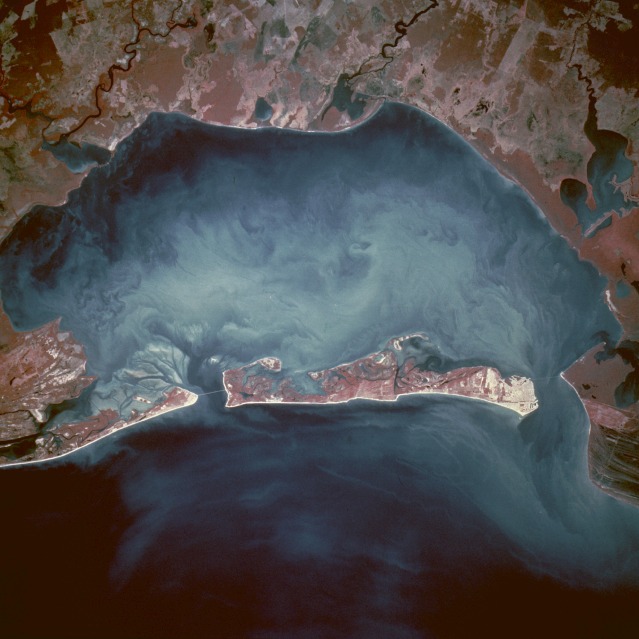 |
| This color infrared, near-vertical photograph of Laguna de TZrminos shows a sediment-laden lagoon that is partially bordered on one side by Carmen Island. The dynamics of the surface currents within the lagoon are revealed by the turbidity patterns in the water. Cuidad del Carmen, with a population of approximately 50 000 on the western tip of Carmen Island, has excellent port facilities that handle approximately 20 percent of Mexico's total petroleum exports. Apparently bridges on either end of the island connect the island with the mainland. The lagoon, recognized as a critical wetland area, is listed among the highest ranked habitats in Mexico for its ability to sustain a variety of plants and animals. Several small, short-flowing rivers enter the lagoon from the mainland along the south side of the lagoon. As industry develops along the southern shore of the lagoon, ecologists and environmentalists will monitor discharges into this environmentally sensitive area. The Bay of Campeche, a southern extension of the Gulf of Mexico, is the water body along the northern coast of Carmen Island. |
| Images: | All Available Images Low-Resolution 93k |
|
| Mission: | STS075 |
|
| Roll - Frame: | 759 - 21 |
|
| Geographical Name: | MEXICO |
|
| Features: | LAG. DE TERMINOS,SED.,IS |
|
| Center Lat x Lon: | 18.5N x 91.5W |
|
| Film Exposure: | N | N=Normal exposure, U=Under exposed, O=Over exposed, F=out of Focus |
| Percentage of Cloud Cover-CLDP: | 0 |
|
| Camera:: | HB |
|
| Camera Tilt: | 27 | LO=Low Oblique, HO=High Oblique, NV=Near Vertical |
| Camera Focal Length: | 250 |
|
| Nadir to Photo Center Direction: | W | The direction from the nadir to the center point, N=North, S=South, E=East, W=West |
| Stereo?: | N | Y=Yes there is an adjacent picture of the same area, N=No there isn't |
| Orbit Number: | 222 |
|
| Date: | 19960307 | YYYYMMDD |
| Time: | 164114 | GMT HHMMSS |
| Nadir Lat: | 18.3N |
Latitude of suborbital point of spacecraft |
| Nadir Lon: | 90.2W |
Longitude of suborbital point of spacecraft |
| Sun Azimuth: | 134 | Clockwise angle in degrees from north to the sun measured at the nadir point |
| Space Craft Altitude: | 154 | nautical miles |
| Sun Elevation: | 58 | Angle in degrees between the horizon and the sun, measured at the nadir point |
| Land Views: | ISLAND |
|
| Water Views: | LAGOON, BAY, SEDIMENT |
|
| Atmosphere Views: | |
|
| Man Made Views: | URBAN AREA |
|
| City Views: | |
|
Photo is not associated with any sequences | ||
| NASA Home Page |
JSC Home Page |
JSC Digital Image Collection |
Earth Science & Remote Sensing |
|
This service is provided by the International Space Station program and the JSC Earth Science & Remote Sensing Unit, ARES Division, Exploration Integration Science Directorate.

|