
Geographic Region: USA-TEXAS
Feature: HOUSTON, LAKE HOUSTON
|
Geographic Region: USA-TEXAS Feature: HOUSTON, LAKE HOUSTON |
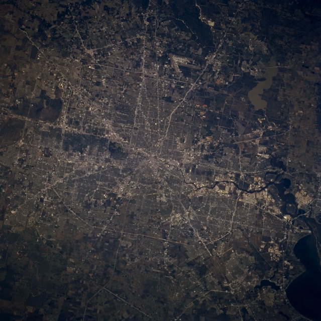 |
| STS075-723-16 Houston, Texas, U.S.A. March 1996 Discernible in this north-looking, low-oblique photograph are numerous transportation arteries that radiate from metropolitan Houston, the fourth most populous city in the United States. Houston is a great financial, industrial, commercial, and medical hub and one of the world's major oil centers. Extending generally eastward from the city center is the snakelike Houston Ship Channel, along which is located one of the world's greatest concentrations of petrochemical and oil refinery industries. The Port of Houston is the third-busiest port in the United States. Metropolitan Houston, with numerous active faults crisscrossing the city, rests on the United States' third largest aquifer and the flat surface of the gulf coastal plain, a giant wedge of mud and sand deposited into the Gulf of Mexico during the last ice age by ancestral Texas rivers. Visible are the runways of George Bush Intercontinental Airport north of the city; sediment-laden Lake Houston to the east; and a small portion of Galveston Bay to the south. |
| Images: | All Available Images Low-Resolution 349k |
|
| Mission: | STS075 |
|
| Roll - Frame: | 723 - 16 |
|
| Geographical Name: | USA-TEXAS |
|
| Features: | HOUSTON, LAKE HOUSTON |
|
| Center Lat x Lon: | 30.0N x 95.5W |
|
| Film Exposure: | N | N=Normal exposure, U=Under exposed, O=Over exposed, F=out of Focus |
| Percentage of Cloud Cover-CLDP: | 0 |
|
| Camera:: | HB |
|
| Camera Tilt: | LO | LO=Low Oblique, HO=High Oblique, NV=Near Vertical |
| Camera Focal Length: | 250 |
|
| Nadir to Photo Center Direction: | NW | The direction from the nadir to the center point, N=North, S=South, E=East, W=West |
| Stereo?: | Y | Y=Yes there is an adjacent picture of the same area, N=No there isn't |
| Orbit Number: | |
|
| Date: | 1996____ | YYYYMMDD |
| Time: | GMT HHMMSS |
|
| Nadir Lat: | N |
Latitude of suborbital point of spacecraft |
| Nadir Lon: | E |
Longitude of suborbital point of spacecraft |
| Sun Azimuth: | Clockwise angle in degrees from north to the sun measured at the nadir point |
|
| Space Craft Altitude: | nautical miles |
|
| Sun Elevation: | Angle in degrees between the horizon and the sun, measured at the nadir point |
|
| Land Views: | PLAIN |
|
| Water Views: | CHANNEL, BAY, LAKE |
|
| Atmosphere Views: | |
|
| Man Made Views: | URBAN AREA, AIRPORT, HIGHWAY |
|
| City Views: | |
|
Photo is not associated with any sequences | ||
| NASA Home Page |
JSC Home Page |
JSC Digital Image Collection |
Earth Science & Remote Sensing |
|
This service is provided by the International Space Station program and the JSC Earth Science & Remote Sensing Unit, ARES Division, Exploration Integration Science Directorate.

|