
Geographic Region: USA-TEXAS
Feature: ROCKPORT,COPANO BAY,COAST
|
Geographic Region: USA-TEXAS Feature: ROCKPORT,COPANO BAY,COAST |
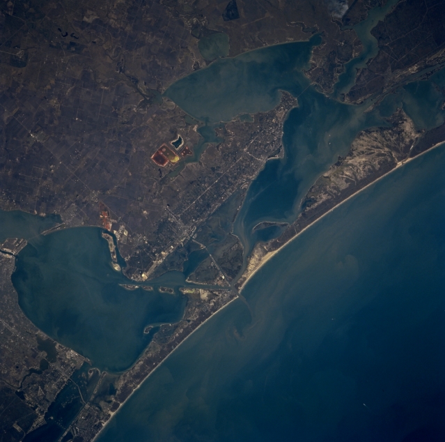 |
| STS075-723-015 Corpus Christi, Aransas Pass, Aransas Bay, and Copano Bay, Texas, U.S.A. March 1996 The coastal area northeast of Corpus Christi is featured in this north-northwest-looking, low-oblique photograph. Apparent are many shallow, sediment-laden bays, some only 3 to 4 feet (1 meter) deep, that are former river mouths inundated by rising sea levels since the last ice age. The bays are rich in marine life and host large populations of winter birds that descend yearly on Aransas National Wildlife Refuge (upper right). The exquisite whopping cranes, which are gradually fighting their way back from extinction, winter at the refuge. Viewing in a northeast arc from Corpus Christi Bay (bottom left) are Copano Bay, Aransas Bay, and Saint Charles Bay. Discernible south to north are the barrier islands of Mustang, east of Corpus Christi; Saint Joseph; and extreme western Matagorda. The Gulf of Mexico is apparent. |
| Images: | All Available Images Low-Resolution 264k |
|
| Mission: | STS075 |
|
| Roll - Frame: | 723 - 15 |
|
| Geographical Name: | USA-TEXAS |
|
| Features: | ROCKPORT,COPANO BAY,COAST |
|
| Center Lat x Lon: | 28.0N x 97W |
|
| Film Exposure: | N | N=Normal exposure, U=Under exposed, O=Over exposed, F=out of Focus |
| Percentage of Cloud Cover-CLDP: | 0 |
|
| Camera:: | HB |
|
| Camera Tilt: | LO | LO=Low Oblique, HO=High Oblique, NV=Near Vertical |
| Camera Focal Length: | 250 |
|
| Nadir to Photo Center Direction: | NW | The direction from the nadir to the center point, N=North, S=South, E=East, W=West |
| Stereo?: | Y | Y=Yes there is an adjacent picture of the same area, N=No there isn't |
| Orbit Number: | |
|
| Date: | 1996____ | YYYYMMDD |
| Time: | GMT HHMMSS |
|
| Nadir Lat: | N |
Latitude of suborbital point of spacecraft |
| Nadir Lon: | E |
Longitude of suborbital point of spacecraft |
| Sun Azimuth: | Clockwise angle in degrees from north to the sun measured at the nadir point |
|
| Space Craft Altitude: | nautical miles |
|
| Sun Elevation: | Angle in degrees between the horizon and the sun, measured at the nadir point |
|
| Land Views: | COAST, PLAIN |
|
| Water Views: | SEDIMENT, BAY |
|
| Atmosphere Views: | |
|
| Man Made Views: | |
|
| City Views: | |
|
Photo is not associated with any sequences | ||
| NASA Home Page |
JSC Home Page |
JSC Digital Image Collection |
Earth Science & Remote Sensing |
|
This service is provided by the International Space Station program and the JSC Earth Science & Remote Sensing Unit, ARES Division, Exploration Integration Science Directorate.

|