Geographic Region: VIETNAM
Feature: MEKONG DELTA, SED. PLUME
|
Geographic Region: VIETNAM Feature: MEKONG DELTA, SED. PLUME |
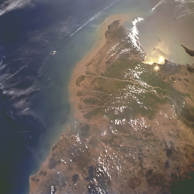 |
| STS075-721-047 Mekong River Delta, Vietnam February 1996 This southwest-looking, low-oblique photograph shows the lower Mekong River and its vast delta. Rising on the Plateau of Tibet, the Mekong flows generally southeast for 2600 miles (4160 kilometers) and empties into the South China Sea through a large delta. The Mekong River Delta covers 75 000 square miles (194 250 square kilometers), and, with its many channels still depositing sediment, the delta continues to grow. The vast swampy delta, crisscrossed by many channels and canals, is one of the greatest rice-growing regions of Asia. Even though rainfall is heavy during the summer months, winters are dry and require irrigation for most of the rice-growing area. The Mekong River Delta was the scene of heavy fighting during the Vietnam War. Barely discernible northwest of the delta is Ho Chi Minh City, formerly Saigon. Point Cau Mau, the southern tip of Vietnam, is visible southwest of the delta. |
| Images: | All Available Images Low-Resolution 101k |
|
| Mission: | STS075 |
|
| Roll - Frame: | 721 - 47 |
|
| Geographical Name: | VIETNAM |
|
| Features: | MEKONG DELTA, SED. PLUME |
|
| Center Lat x Lon: | 10.0N x 106.5E |
|
| Film Exposure: | N | N=Normal exposure, U=Under exposed, O=Over exposed, F=out of Focus |
| Percentage of Cloud Cover-CLDP: | 5 |
|
| Camera:: | HB |
|
| Camera Tilt: | LO | LO=Low Oblique, HO=High Oblique, NV=Near Vertical |
| Camera Focal Length: | 40 |
|
| Nadir to Photo Center Direction: | The direction from the nadir to the center point, N=North, S=South, E=East, W=West |
|
| Stereo?: | N | Y=Yes there is an adjacent picture of the same area, N=No there isn't |
| Orbit Number: | |
|
| Date: | 1996____ | YYYYMMDD |
| Time: | GMT HHMMSS |
|
| Nadir Lat: | N |
Latitude of suborbital point of spacecraft |
| Nadir Lon: | E |
Longitude of suborbital point of spacecraft |
| Sun Azimuth: | Clockwise angle in degrees from north to the sun measured at the nadir point |
|
| Space Craft Altitude: | nautical miles |
|
| Sun Elevation: | Angle in degrees between the horizon and the sun, measured at the nadir point |
|
| Land Views: | COAST, CAPE, PLAIN, MOUNTAIN, FOREST |
|
| Water Views: | RIVER, DELTA, SEDIMENT, SEA |
|
| Atmosphere Views: | |
|
| Man Made Views: | AGRICULTURE, DEFORESTATION |
|
| City Views: | |
|
Photo is not associated with any sequences | ||
| NASA Home Page |
JSC Home Page |
JSC Digital Image Collection |
Earth Science & Remote Sensing |
|
This service is provided by the International Space Station program and the JSC Earth Science & Remote Sensing Unit, ARES Division, Exploration Integration Science Directorate.

|