Geographic Region: CHINA
Feature: COAST, EAST OF HONG KONG
|
Geographic Region: CHINA Feature: COAST, EAST OF HONG KONG |
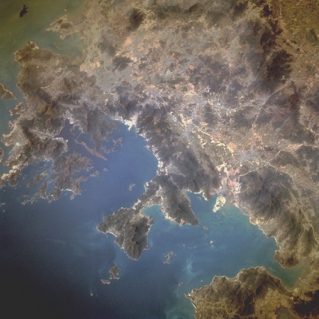 |
| STS075-719-007 Shenzhen, China February 1996 The indented, serrated coastline near Hong Kong--typical of the entire southeast coastline of China with its jagged peninsulas, countless bays, outstanding natural harbors, and thousands of coastal islands--is captured in this near-vertical photograph around Daya Bay (northernmost) and Mirs Bay. The darker areas are low mountains that range from 2000 to more than 3000 feet (610 to more than 915 meters) above sea level. The real story is the economic development that continues in the British Crown Colony of Hong Kong (part of which is shown along the southwest edge of the photograph)--specifically, Kowloon Peninsula and the New Territories. This economic development, and the imminent return of Hong Kong to Chinese control, has also stimulated growth in neighboring cities. Immediately north of the New Territories lies Shenzhen, China. In 1980, Shenzhen was a sleepy fishing and duck farming village of 20 000; in 1994, the population had surpassed 2.5 million--perhaps making this the fastest growing urban center on Earth. The thin, lighter lines are roads or railroads that are being constructed to connect developing Shenzhen with other parts of southeast China. This photograph shows that other urban areas near Shenzhen are also beginning to share in the economic prosperity that has resulted from China's new "open-door" policy to attract overseas technology and investment. |
| Images: | All Available Images Low-Resolution 121k |
|
| Mission: | STS075 |
|
| Roll - Frame: | 719 - 7 |
|
| Geographical Name: | CHINA |
|
| Features: | COAST, EAST OF HONG KONG |
|
| Center Lat x Lon: | 22.5N x 114.5E |
|
| Film Exposure: | N | N=Normal exposure, U=Under exposed, O=Over exposed, F=out of Focus |
| Percentage of Cloud Cover-CLDP: | 0 |
|
| Camera:: | HB |
|
| Camera Tilt: | LO | LO=Low Oblique, HO=High Oblique, NV=Near Vertical |
| Camera Focal Length: | 250 |
|
| Nadir to Photo Center Direction: | The direction from the nadir to the center point, N=North, S=South, E=East, W=West |
|
| Stereo?: | N | Y=Yes there is an adjacent picture of the same area, N=No there isn't |
| Orbit Number: | |
|
| Date: | 1996____ | YYYYMMDD |
| Time: | GMT HHMMSS |
|
| Nadir Lat: | N |
Latitude of suborbital point of spacecraft |
| Nadir Lon: | E |
Longitude of suborbital point of spacecraft |
| Sun Azimuth: | Clockwise angle in degrees from north to the sun measured at the nadir point |
|
| Space Craft Altitude: | nautical miles |
|
| Sun Elevation: | Angle in degrees between the horizon and the sun, measured at the nadir point |
|
| Land Views: | COAST, MOUNTAIN, VALLEY, PENINSULA, CAPE |
|
| Water Views: | BAY, SEA, ESTUARY |
|
| Atmosphere Views: | |
|
| Man Made Views: | URBAN AREA |
|
| City Views: | |
|
Photo is not associated with any sequences | ||
| NASA Home Page |
JSC Home Page |
JSC Digital Image Collection |
Earth Science & Remote Sensing |
|
This service is provided by the International Space Station program and the JSC Earth Science & Remote Sensing Unit, ARES Division, Exploration Integration Science Directorate.

|