
Geographic Region: VENEZUELA
Feature: BAY OF ABLAZO, MARACAIBO
|
Geographic Region: VENEZUELA Feature: BAY OF ABLAZO, MARACAIBO |
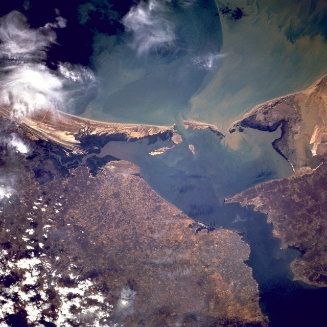 |
| STS075-706-038 Maracaibo, Venezuela February 1996 This south-southwest-looking, low-oblique photograph shows the Bay of Tablazo and the city of Maracaibo at the entrance into Lake Maracaibo. Maracaibo, the oil capital of South America, is the second largest city in Venezuela. The city is situated on the western side of the channel connecting Lake Maracaibo and the Gulf of Venezuela, which goes into the Caribbean Sea, and serves the rich oil-producing area of northwestern Venezuela. Besides oil, the city exports shrimp, coffee, cacao, sugar, and hardwood. With an average temperature of 82 degrees Fahrenheit (28 degrees Celsius) and high humidity, Maracaibo has one of the least attractive climates in the world; however, air conditioning mitigates the discomfort. The city is thoroughly modern with wide streets and impressive buildings. |
| Images: | All Available Images Low-Resolution 132k |
|
| Mission: | STS075 |
|
| Roll - Frame: | 706 - 38 |
|
| Geographical Name: | VENEZUELA |
|
| Features: | BAY OF ABLAZO, MARACAIBO |
|
| Center Lat x Lon: | 11.0N x 71.5W |
|
| Film Exposure: | N | N=Normal exposure, U=Under exposed, O=Over exposed, F=out of Focus |
| Percentage of Cloud Cover-CLDP: | 15 |
|
| Camera:: | HB |
|
| Camera Tilt: | 28 | LO=Low Oblique, HO=High Oblique, NV=Near Vertical |
| Camera Focal Length: | 250 |
|
| Nadir to Photo Center Direction: | S | The direction from the nadir to the center point, N=North, S=South, E=East, W=West |
| Stereo?: | Y | Y=Yes there is an adjacent picture of the same area, N=No there isn't |
| Orbit Number: | 128 |
|
| Date: | 19960301 | YYYYMMDD |
| Time: | 193848 | GMT HHMMSS |
| Nadir Lat: | 12.3N |
Latitude of suborbital point of spacecraft |
| Nadir Lon: | 71W |
Longitude of suborbital point of spacecraft |
| Sun Azimuth: | 246 | Clockwise angle in degrees from north to the sun measured at the nadir point |
| Space Craft Altitude: | 157 | nautical miles |
| Sun Elevation: | 45 | Angle in degrees between the horizon and the sun, measured at the nadir point |
| Land Views: | COAST, HILL |
|
| Water Views: | GULF, LAKE, CHANNEL |
|
| Atmosphere Views: | |
|
| Man Made Views: | URBAN AREA |
|
| City Views: | MARACAIBO |
|
Photo is not associated with any sequences | ||
| NASA Home Page |
JSC Home Page |
JSC Digital Image Collection |
Earth Science & Remote Sensing |
|
This service is provided by the International Space Station program and the JSC Earth Science & Remote Sensing Unit, ARES Division, Exploration Integration Science Directorate.

|