Geographic Region: BANGLADESH
Feature: PAN-BRAHMAPUTRA RIVER
|
Geographic Region: BANGLADESH Feature: PAN-BRAHMAPUTRA RIVER |
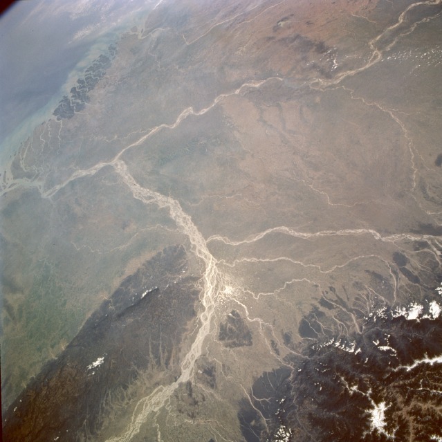 |
| STS075-705-057 Brahmaputra and Ganges Rivers, India February 1996 The confluence of two of south Asia's great rivers, the Brahmaputra and the Ganges, is visible near the southern edge of this southwestern-looking, high-oblique photograph. The Sun's reflection off the water (sunglint) helps identify many water channels within the floodplain of the Brahmaputra River as it curves around the heavily forested Khasi Hills of northeast India. Easily distinguished are the Brahmaputra's tributaries that flow generally southward off the foothills of the Himalaya Mountains and the southeasterly-flowing Ganges' multibraided channels and numerous sandbars. These two great rivers merge in the small, low-lying country of Bangladesh, most of which is shown in this photograph. The Sundarbans, the most extensive mangrove forest in the world and the habitat for the endangered Bengal tiger, is the dark area in the extensive delta created along the northern edge of the Bay of Bengal. Because large quantities of fertile soils are deposited in the delta and throughout Bangladesh, this heavily populated region is well endowed with rich soils for farming; however, the monsoons can produce devastating damage and loss of human life, especially for the people in the flood-prone, low-lying area. |
| Images: | All Available Images Low-Resolution 106k |
|
| Mission: | STS075 |
|
| Roll - Frame: | 705 - 57 |
|
| Geographical Name: | BANGLADESH |
|
| Features: | PAN-BRAHMAPUTRA RIVER |
|
| Center Lat x Lon: | 25.5N x 89.5E |
|
| Film Exposure: | N | N=Normal exposure, U=Under exposed, O=Over exposed, F=out of Focus |
| Percentage of Cloud Cover-CLDP: | 5 |
|
| Camera:: | HB |
|
| Camera Tilt: | HO | LO=Low Oblique, HO=High Oblique, NV=Near Vertical |
| Camera Focal Length: | 50 |
|
| Nadir to Photo Center Direction: | S | The direction from the nadir to the center point, N=North, S=South, E=East, W=West |
| Stereo?: | Y | Y=Yes there is an adjacent picture of the same area, N=No there isn't |
| Orbit Number: | 119 |
|
| Date: | 19960301 | YYYYMMDD |
| Time: | 055507 | GMT HHMMSS |
| Nadir Lat: | 27.6N |
Latitude of suborbital point of spacecraft |
| Nadir Lon: | 89.6E |
Longitude of suborbital point of spacecraft |
| Sun Azimuth: | 172 | Clockwise angle in degrees from north to the sun measured at the nadir point |
| Space Craft Altitude: | 154 | nautical miles |
| Sun Elevation: | 55 | Angle in degrees between the horizon and the sun, measured at the nadir point |
| Land Views: | MOUNTAIN, VALLEY, HILL, FOREST |
|
| Water Views: | RIVER, BAY, DELTA, SUNGLINT |
|
| Atmosphere Views: | |
|
| Man Made Views: | |
|
| City Views: | |
|
Photo is not associated with any sequences | ||
| NASA Home Page |
JSC Home Page |
JSC Digital Image Collection |
Earth Science & Remote Sensing |
|
This service is provided by the International Space Station program and the JSC Earth Science & Remote Sensing Unit, ARES Division, Exploration Integration Science Directorate.

|