
Geographic Region: IRAN
Feature: QESHM I.,RIVERS,SED.,IS.
|
Geographic Region: IRAN Feature: QESHM I.,RIVERS,SED.,IS. |
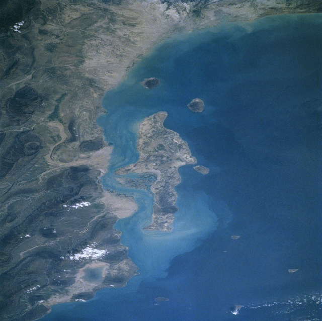 |
| STS075-702-049 Qeshm Island, Iran March 1996 Strategically located in the Strait of Hormuz, the Iranian island of Qeshm can be seen in this west-looking view. The largest island in Iran, Qeshm covers an area of 500 square miles (1295 sq km). Clarence Strait separates mainland Iran from Qeshm Island. Qeshm Island is a mostly rocky and barren island with a small human population. On what little cultivated land there is, dates and melons are grown. The linear mountains of the Zagros are visible covering the right quarter of the image. Near the upper right of the image, the shallow and sometimes dry Mehrakan Salt Lake is visible. Just off the coast in the upper center of the image is Forur Island. To Forur Island's left (south) is the Island of Sirri, once an Iranian oil terminal. To the east of Sirri and in the upper left of the image is the island of Agu Musa and to its right is Tung Island. The rather hilly, barren islands just to the east of Qeshm Island are Hormoz and Larak Islands. |
| Images: | All Available Images Low-Resolution 332k |
|
| Mission: | STS075 |
|
| Roll - Frame: | 702 - 49 |
|
| Geographical Name: | IRAN |
|
| Features: | QESHM I.,RIVERS,SED.,IS. |
|
| Center Lat x Lon: | 27.0N x 56.0E |
|
| Film Exposure: | N | N=Normal exposure, U=Under exposed, O=Over exposed, F=out of Focus |
| Percentage of Cloud Cover-CLDP: | 5 |
|
| Camera:: | HB |
|
| Camera Tilt: | LO | LO=Low Oblique, HO=High Oblique, NV=Near Vertical |
| Camera Focal Length: | 100 |
|
| Nadir to Photo Center Direction: | W | The direction from the nadir to the center point, N=North, S=South, E=East, W=West |
| Stereo?: | Y | Y=Yes there is an adjacent picture of the same area, N=No there isn't |
| Orbit Number: | 26 |
|
| Date: | 19960224 | YYYYMMDD |
| Time: | 100023 | GMT HHMMSS |
| Nadir Lat: | 28.6N |
Latitude of suborbital point of spacecraft |
| Nadir Lon: | 60.8E |
Longitude of suborbital point of spacecraft |
| Sun Azimuth: | 219 | Clockwise angle in degrees from north to the sun measured at the nadir point |
| Space Craft Altitude: | 160 | nautical miles |
| Sun Elevation: | 44 | Angle in degrees between the horizon and the sun, measured at the nadir point |
| Land Views: | ISLAND, MOUNTAIN |
|
| Water Views: | GULF, STRAIT, PLAYA |
|
| Atmosphere Views: | |
|
| Man Made Views: | |
|
| City Views: | |
|
Photo is not associated with any sequences | ||
| NASA Home Page |
JSC Home Page |
JSC Digital Image Collection |
Earth Science & Remote Sensing |
|
This service is provided by the International Space Station program and the JSC Earth Science & Remote Sensing Unit, ARES Division, Exploration Integration Science Directorate.

|