Geographic Region: GERMANY
Feature: RHEIN RIVER, STRIP MINES
|
Geographic Region: GERMANY Feature: RHEIN RIVER, STRIP MINES |
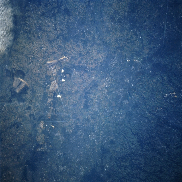 |
| STS074-734-008 Rhine River Valley, Germany November, 1995 The meandering Rhine River, carrying more traffic than any other waterway in the world, can be seen traversing the scene from lower left (south) to the upper right corner (north) of the image. The Rhine River is one of the principal rivers of Europe and is 820 miles (1320 km) long. Passing through Cologne (Koln) near the bottom center of the image and Dusseldorf (just right of the center), the Rhine flows across the North German plain as a broad, slow flowing river on a bed of ancient deltaic deposits left by ancestors of the modern river. Both Cologne and Dusseldorf are major industrial, financial, and commercial cities. The cities are also busy river ports and important transportation hubs. Brown coal strip mines ground scars are visible to the west (left) of the river. A jet contrail (straight white line) is discernible extending from the upper left toward the center of the image. |
| Images: | All Available Images Low-Resolution 346k |
|
| Mission: | STS074 |
|
| Roll - Frame: | 734 - 8 |
|
| Geographical Name: | GERMANY |
|
| Features: | RHEIN RIVER, STRIP MINES |
|
| Center Lat x Lon: | 51.0N x 7.0E |
|
| Film Exposure: | U | N=Normal exposure, U=Under exposed, O=Over exposed, F=out of Focus |
| Percentage of Cloud Cover-CLDP: | 5 |
|
| Camera:: | HB |
|
| Camera Tilt: | 5 | LO=Low Oblique, HO=High Oblique, NV=Near Vertical |
| Camera Focal Length: | 250 |
|
| Nadir to Photo Center Direction: | S | The direction from the nadir to the center point, N=North, S=South, E=East, W=West |
| Stereo?: | N | Y=Yes there is an adjacent picture of the same area, N=No there isn't |
| Orbit Number: | 15 |
|
| Date: | 19951113 | YYYYMMDD |
| Time: | 095757 | GMT HHMMSS |
| Nadir Lat: | 51.2N |
Latitude of suborbital point of spacecraft |
| Nadir Lon: | 6.9E |
Longitude of suborbital point of spacecraft |
| Sun Azimuth: | 160 | Clockwise angle in degrees from north to the sun measured at the nadir point |
| Space Craft Altitude: | 167 | nautical miles |
| Sun Elevation: | 19 | Angle in degrees between the horizon and the sun, measured at the nadir point |
| Land Views: | PLAIN, VALLEY, HILL |
|
| Water Views: | RIVER |
|
| Atmosphere Views: | |
|
| Man Made Views: | URBAN AREA, MINING |
|
| City Views: | COLOGNE, DUSSELDORF |
|
Photo is not associated with any sequences | ||
| NASA Home Page |
JSC Home Page |
JSC Digital Image Collection |
Earth Science & Remote Sensing |
|
This service is provided by the International Space Station program and the JSC Earth Science & Remote Sensing Unit, ARES Division, Exploration Integration Science Directorate.

|