Geographic Region: CANADA-A
Feature: CALGARY,AGR.,SNOW,BOW R.
|
Geographic Region: CANADA-A Feature: CALGARY,AGR.,SNOW,BOW R. |
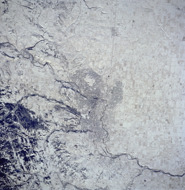 |
| STS074-714-003 Calgary Area, Alberta, Canada November 1995 The snow covered landscape surrounding Calgary makes this image look like a black and white picture and helps to identify the Bow River, running diagonally from northwest to southeast through downtown Calgary. Two tributaries of the Bow River that originate in the foothills of the Canadian Rocky Mountains are accentuated as they flow out of the darker, hilly area southwest of the city. Highway 2 (thin, dark, linear feature) bypasses Calgary International Airport to its west, and north of the darker, central business district of Calgary. Then the highway heads north through the small community of Airdrie, on its way to the city of Edmonton (not in this scene). |
| Images: | All Available Images Low-Resolution 352k |
|
| Mission: | STS074 |
|
| Roll - Frame: | 714 - 3 |
|
| Geographical Name: | CANADA-A |
|
| Features: | CALGARY,AGR.,SNOW,BOW R. |
|
| Center Lat x Lon: | 51.0N x 114W |
|
| Film Exposure: | N | N=Normal exposure, U=Under exposed, O=Over exposed, F=out of Focus |
| Percentage of Cloud Cover-CLDP: | 0 |
|
| Camera:: | HB |
|
| Camera Tilt: | 16 | LO=Low Oblique, HO=High Oblique, NV=Near Vertical |
| Camera Focal Length: | 250 |
|
| Nadir to Photo Center Direction: | S | The direction from the nadir to the center point, N=North, S=South, E=East, W=West |
| Stereo?: | Y | Y=Yes there is an adjacent picture of the same area, N=No there isn't |
| Orbit Number: | 5 |
|
| Date: | 19951112 | YYYYMMDD |
| Time: | 185048 | GMT HHMMSS |
| Nadir Lat: | 51.8N |
Latitude of suborbital point of spacecraft |
| Nadir Lon: | 114W |
Longitude of suborbital point of spacecraft |
| Sun Azimuth: | 172 | Clockwise angle in degrees from north to the sun measured at the nadir point |
| Space Craft Altitude: | 169 | nautical miles |
| Sun Elevation: | 20 | Angle in degrees between the horizon and the sun, measured at the nadir point |
| Land Views: | |
|
| Water Views: | RIVER |
|
| Atmosphere Views: | |
|
| Man Made Views: | URBAN AREA, HIGHWAY, AIRPORT |
|
| City Views: | |
|
Photo is not associated with any sequences | ||
| NASA Home Page |
JSC Home Page |
JSC Digital Image Collection |
Earth Science & Remote Sensing |
|
This service is provided by the International Space Station program and the JSC Earth Science & Remote Sensing Unit, ARES Division, Exploration Integration Science Directorate.

|