
Geographic Region: USA-CALIFORNIA
Feature: EDWARDS AFB, MOJAVE DES.
|
Geographic Region: USA-CALIFORNIA Feature: EDWARDS AFB, MOJAVE DES. |
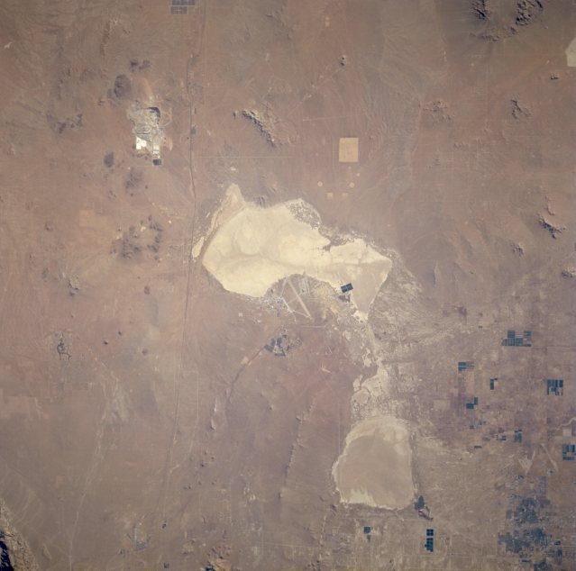 |
| STS073-760-026 Rogers Dry Lake, California, U.S.A. October 1995 Highly reflective Rogers Dry Lake, near the center of the photograph, is composed of a hard clay surface so strong that the NASA fleet of Space Shuttles uses this facility as an alternate landing site. Discernible are several manmade features surrounding the lake--one of the major runways of Edwards Air Force Base, west of the lake; California Highway 58, the thin east-west artery to the north; borax mining and mineral extraction plants to the northeast; light and dark field patterns of irrigated agriculture to the south and southwest; and Rosamond Dry Lake to the southwest. |
| Images: | All Available Images Low-Resolution 263k |
|
| Mission: | STS073 |
|
| Roll - Frame: | 760 - 26 |
|
| Geographical Name: | USA-CALIFORNIA |
|
| Features: | EDWARDS AFB, MOJAVE DES. |
|
| Center Lat x Lon: | 35.0N x 118W |
|
| Film Exposure: | N | N=Normal exposure, U=Under exposed, O=Over exposed, F=out of Focus |
| Percentage of Cloud Cover-CLDP: | 0 |
|
| Camera:: | HB |
|
| Camera Tilt: | 9 | LO=Low Oblique, HO=High Oblique, NV=Near Vertical |
| Camera Focal Length: | 250 |
|
| Nadir to Photo Center Direction: | NE | The direction from the nadir to the center point, N=North, S=South, E=East, W=West |
| Stereo?: | N | Y=Yes there is an adjacent picture of the same area, N=No there isn't |
| Orbit Number: | 164 |
|
| Date: | 19951030 | YYYYMMDD |
| Time: | 163502 | GMT HHMMSS |
| Nadir Lat: | 34.8N |
Latitude of suborbital point of spacecraft |
| Nadir Lon: | 118.3W |
Longitude of suborbital point of spacecraft |
| Sun Azimuth: | 130 | Clockwise angle in degrees from north to the sun measured at the nadir point |
| Space Craft Altitude: | 142 | nautical miles |
| Sun Elevation: | 25 | Angle in degrees between the horizon and the sun, measured at the nadir point |
| Land Views: | DESERT |
|
| Water Views: | PLAYA |
|
| Atmosphere Views: | |
|
| Man Made Views: | AIRPORT |
|
| City Views: | |
|
Photo is not associated with any sequences | ||
| NASA Home Page |
JSC Home Page |
JSC Digital Image Collection |
Earth Science & Remote Sensing |
|
This service is provided by the International Space Station program and the JSC Earth Science & Remote Sensing Unit, ARES Division, Exploration Integration Science Directorate.

|