
Geographic Region: AUSTRALIA-Q
Feature: WEIPA, ALBATROSS BAY
|
Geographic Region: AUSTRALIA-Q Feature: WEIPA, ALBATROSS BAY |
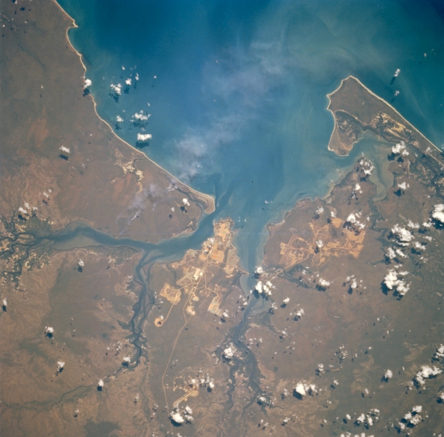 |
| STS073-759-093 Weipa Area, Queensland, Australia October 1995 Located on the eastern side of the Gulf of Carpentaria and on the west coast of the Cape York Peninsula, Weipa is situated along the northern coast of a peninsula that is bordered by the Mission River (north) and Embley River (south), which rise in the Great Dividing Range. The light colored areas show the locations of the large bauxite mining operation that exploits one of the richest bauxite deposits in the world. The runway (linear, light-colored feature near the southern edge of the peninsula where the mining scars are prominent) of Weipa Airport is visible. Several smoke plumes, probably from range burning, are also visible (left of center). |
| Images: | All Available Images Low-Resolution 297k |
|
| Mission: | STS073 |
|
| Roll - Frame: | 759 - 93 |
|
| Geographical Name: | AUSTRALIA-Q |
|
| Features: | WEIPA, ALBATROSS BAY |
|
| Center Lat x Lon: | 12.5S x 142.0E |
|
| Film Exposure: | N | N=Normal exposure, U=Under exposed, O=Over exposed, F=out of Focus |
| Percentage of Cloud Cover-CLDP: | 5 |
|
| Camera:: | HB |
|
| Camera Tilt: | 26 | LO=Low Oblique, HO=High Oblique, NV=Near Vertical |
| Camera Focal Length: | 250 |
|
| Nadir to Photo Center Direction: | E | The direction from the nadir to the center point, N=North, S=South, E=East, W=West |
| Stereo?: | N | Y=Yes there is an adjacent picture of the same area, N=No there isn't |
| Orbit Number: | 140 |
|
| Date: | 19951029 | YYYYMMDD |
| Time: | 050331 | GMT HHMMSS |
| Nadir Lat: | 12.9S |
Latitude of suborbital point of spacecraft |
| Nadir Lon: | 140.9E |
Longitude of suborbital point of spacecraft |
| Sun Azimuth: | 265 | Clockwise angle in degrees from north to the sun measured at the nadir point |
| Space Craft Altitude: | 146 | nautical miles |
| Sun Elevation: | 50 | Angle in degrees between the horizon and the sun, measured at the nadir point |
| Land Views: | PENINSULA |
|
| Water Views: | GULF, BAY |
|
| Atmosphere Views: | SMOKE |
|
| Man Made Views: | MINING, AIRPORT |
|
| City Views: | |
|
Photo is not associated with any sequences | ||
| NASA Home Page |
JSC Home Page |
JSC Digital Image Collection |
Earth Science & Remote Sensing |
|
This service is provided by the International Space Station program and the JSC Earth Science & Remote Sensing Unit, ARES Division, Exploration Integration Science Directorate.

|