
Geographic Region: USA-LOUISIANA
Feature: NEW ORLEANS,LAKES,BRIDGE
|
Geographic Region: USA-LOUISIANA Feature: NEW ORLEANS,LAKES,BRIDGE |
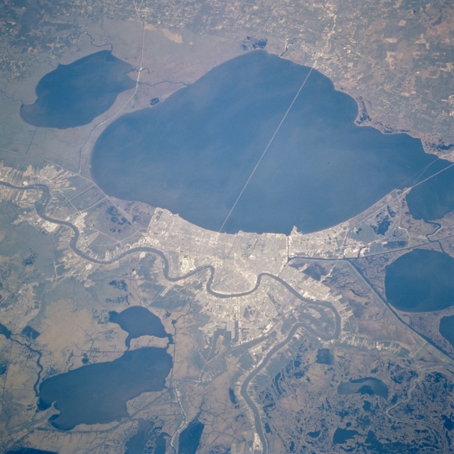 |
| STS073-759-032 Lake Pontchartrain, Louisiana, U.S.A. October 1995 Water surrounding greater metropolitan New Orleans is featured in this north-looking photograph. Apparent are Lake Maurepas, the small body of water to the west that flows into Lake Pontchartrain, and Lake Salvador, the large lake south of New Orleans. The 24-mile (39-kilometer) causeway that connects New Orleans with communities on the north shore of Lake Pontchartrain bisects this large, relatively shallow lake whose average depth is 12 feet (3.6 meters). Most of the darker areas are standing water, swamps, and marshlands; the dark, linear features are canals. The meandering Mississippi River is easily discernible as it flows south to the Gulf of Mexico. |
| Images: | All Available Images Low-Resolution 317k |
|
| Mission: | STS073 |
|
| Roll - Frame: | 759 - 32 |
|
| Geographical Name: | USA-LOUISIANA |
|
| Features: | NEW ORLEANS,LAKES,BRIDGE |
|
| Center Lat x Lon: | 30.0N x 90W |
|
| Film Exposure: | N | N=Normal exposure, U=Under exposed, O=Over exposed, F=out of Focus |
| Percentage of Cloud Cover-CLDP: | 0 |
|
| Camera:: | HB |
|
| Camera Tilt: | 36 | LO=Low Oblique, HO=High Oblique, NV=Near Vertical |
| Camera Focal Length: | 250 |
|
| Nadir to Photo Center Direction: | N | The direction from the nadir to the center point, N=North, S=South, E=East, W=West |
| Stereo?: | N | Y=Yes there is an adjacent picture of the same area, N=No there isn't |
| Orbit Number: | 132 |
|
| Date: | 19951028 | YYYYMMDD |
| Time: | 164835 | GMT HHMMSS |
| Nadir Lat: | 28.4N |
Latitude of suborbital point of spacecraft |
| Nadir Lon: | 89.3W |
Longitude of suborbital point of spacecraft |
| Sun Azimuth: | 161 | Clockwise angle in degrees from north to the sun measured at the nadir point |
| Space Craft Altitude: | 144 | nautical miles |
| Sun Elevation: | 47 | Angle in degrees between the horizon and the sun, measured at the nadir point |
| Land Views: | PLAIN |
|
| Water Views: | LAKE, RIVER, CANAL, SWAMP |
|
| Atmosphere Views: | |
|
| Man Made Views: | URBAN AREA, HIGHWAY |
|
| City Views: | |
|
Photo is not associated with any sequences | ||
| NASA Home Page |
JSC Home Page |
JSC Digital Image Collection |
Earth Science & Remote Sensing |
|
This service is provided by the International Space Station program and the JSC Earth Science & Remote Sensing Unit, ARES Division, Exploration Integration Science Directorate.

|