
Geographic Region: AUSTRALIA-WA
Feature: EXMOUTH GULF,SED.,DESERT
|
Geographic Region: AUSTRALIA-WA Feature: EXMOUTH GULF,SED.,DESERT |
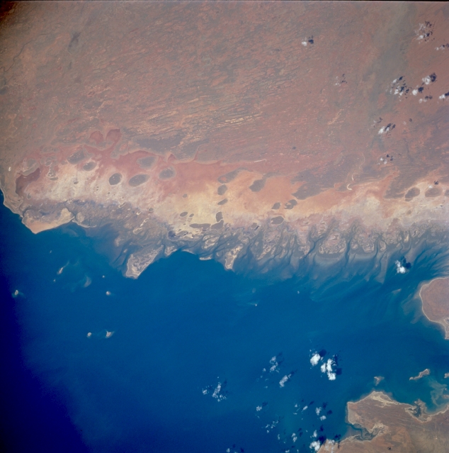 |
| STS073-753-018 Exmouth Gulf, Western Australia, Australia October 1995 Refer to STS073-753-017 for a detailed description of the eastern shore of Exmouth Bay. This picture extends photo coverage northward from STS073-753-017 featuring the eastern shoreline. The dark coastal region supports mangrove trees. Inland are broad expanses of sandy coastal plains. |
| Images: | All Available Images Low-Resolution 271k |
|
| Mission: | STS073 |
|
| Roll - Frame: | 753 - 18 |
|
| Geographical Name: | AUSTRALIA-WA |
|
| Features: | EXMOUTH GULF,SED.,DESERT |
|
| Center Lat x Lon: | 22S x 114.5E |
|
| Film Exposure: | N | N=Normal exposure, U=Under exposed, O=Over exposed, F=out of Focus |
| Percentage of Cloud Cover-CLDP: | 5 |
|
| Camera:: | HB |
|
| Camera Tilt: | 38 | LO=Low Oblique, HO=High Oblique, NV=Near Vertical |
| Camera Focal Length: | 250 |
|
| Nadir to Photo Center Direction: | NE | The direction from the nadir to the center point, N=North, S=South, E=East, W=West |
| Stereo?: | Y | Y=Yes there is an adjacent picture of the same area, N=No there isn't |
| Orbit Number: | 189 |
|
| Date: | 19951101 | YYYYMMDD |
| Time: | 062222 | GMT HHMMSS |
| Nadir Lat: | 23.1S |
Latitude of suborbital point of spacecraft |
| Nadir Lon: | 113.0E |
Longitude of suborbital point of spacecraft |
| Sun Azimuth: | 280 | Clockwise angle in degrees from north to the sun measured at the nadir point |
| Space Craft Altitude: | 145 | nautical miles |
| Sun Elevation: | 58 | Angle in degrees between the horizon and the sun, measured at the nadir point |
| Land Views: | PLAIN |
|
| Water Views: | GULF |
|
| Atmosphere Views: | |
|
| Man Made Views: | |
|
| City Views: | |
|
Photo is not associated with any sequences | ||
| NASA Home Page |
JSC Home Page |
JSC Digital Image Collection |
Earth Science & Remote Sensing |
|
This service is provided by the International Space Station program and the JSC Earth Science & Remote Sensing Unit, ARES Division, Exploration Integration Science Directorate.

|