
Geographic Region: USA-GEORGIA
Feature: L. SIDNEY LANIER,AGR.,CY.
|
Geographic Region: USA-GEORGIA Feature: L. SIDNEY LANIER,AGR.,CY. |
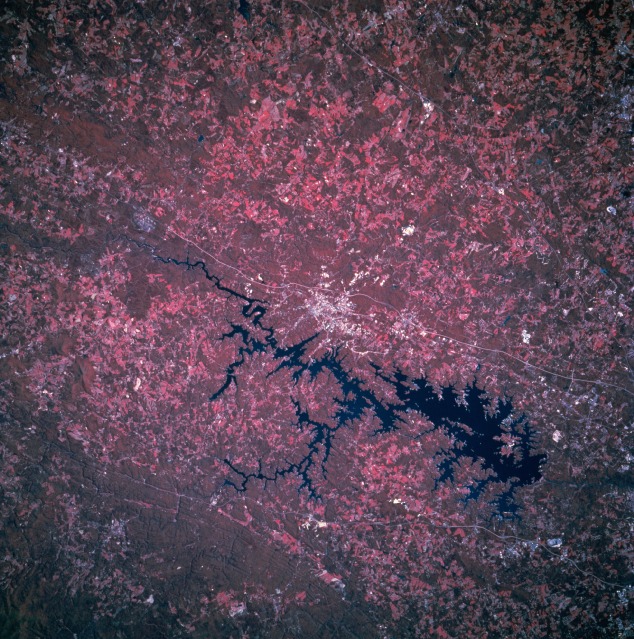 |
| STS073-750-029 Gainesville, Georgia, U.S.A. October 1995 Featured in this color infrared photograph are Lake Sidney Lanier and Gainesville, which lie approximately 50 miles (80 kilometers) northeast of Atlanta. Color infrared film (showing green vegetation as red hues) helps to discriminate land-water boundaries; e.g., using color infrared film in this photograph the extensiveness of surface water is much easier to discern than in photograph STS073-708-014, a noninfrared color film product of the same general geographic area. Forested lands (darker red) and agricultural field patterns (lighter red) are also easier to discriminate using color infrared film. Several manmade features are visible--Interstate Highway 985 east of Gainesville; U. S. Highway 23, which parallels Interstate Highway 985 in some areas; and a thin, linear power line right-of-way through the southern Chattahoochee National Forest (lower left). |
| Images: | All Available Images Low-Resolution 191k |
|
| Mission: | STS073 |
|
| Roll - Frame: | 750 - 29 |
|
| Geographical Name: | USA-GEORGIA |
|
| Features: | L. SIDNEY LANIER,AGR.,CY. |
|
| Center Lat x Lon: | 34.5N x 84W |
|
| Film Exposure: | N | N=Normal exposure, U=Under exposed, O=Over exposed, F=out of Focus |
| Percentage of Cloud Cover-CLDP: | 0 |
|
| Camera:: | HB |
|
| Camera Tilt: | 31 | LO=Low Oblique, HO=High Oblique, NV=Near Vertical |
| Camera Focal Length: | 250 |
|
| Nadir to Photo Center Direction: | W | The direction from the nadir to the center point, N=North, S=South, E=East, W=West |
| Stereo?: | N | Y=Yes there is an adjacent picture of the same area, N=No there isn't |
| Orbit Number: | 84 |
|
| Date: | 19951025 | YYYYMMDD |
| Time: | 165817 | GMT HHMMSS |
| Nadir Lat: | 33.9N |
Latitude of suborbital point of spacecraft |
| Nadir Lon: | 82.7W |
Longitude of suborbital point of spacecraft |
| Sun Azimuth: | 174 | Clockwise angle in degrees from north to the sun measured at the nadir point |
| Space Craft Altitude: | 145 | nautical miles |
| Sun Elevation: | 44 | Angle in degrees between the horizon and the sun, measured at the nadir point |
| Land Views: | FOREST |
|
| Water Views: | RESERVOIR |
|
| Atmosphere Views: | |
|
| Man Made Views: | HIGHWAY, URBAN AREA, AGRICULTURE |
|
| City Views: | |
|
Photo is not associated with any sequences | ||
| NASA Home Page |
JSC Home Page |
JSC Digital Image Collection |
Earth Science & Remote Sensing |
|
This service is provided by the International Space Station program and the JSC Earth Science & Remote Sensing Unit, ARES Division, Exploration Integration Science Directorate.

|