
Geographic Region: USA-VIRGINIA
Feature: BAY, SED.,PENINSULA,AGR.
|
Geographic Region: USA-VIRGINIA Feature: BAY, SED.,PENINSULA,AGR. |
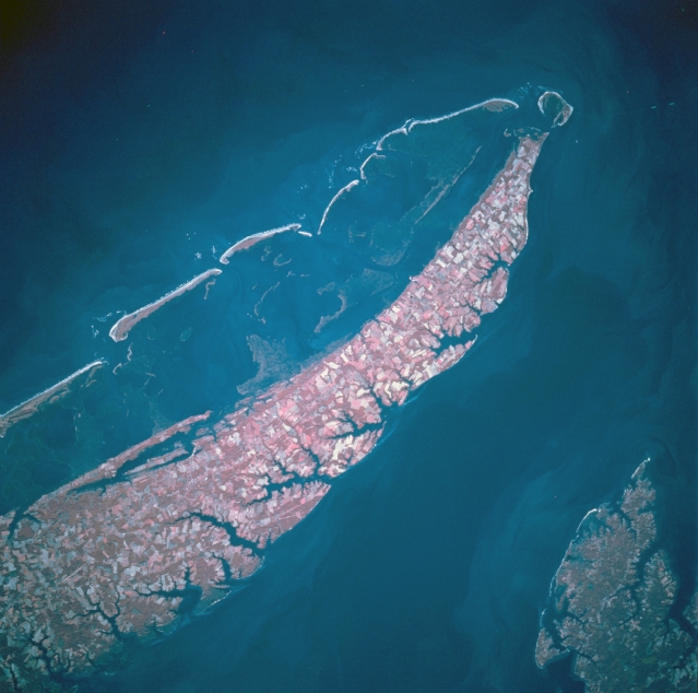 |
| STS073-746-071 Southern Delmarva Peninsula, Cape Charles, Virginia, U.S.A. October 1995 This color infrared, southeast-looking low oblique view shows Cape Charles and the southern portion of the Delmarva Peninsula, Virginia. The western shore of the narrow peninsula facing Chesapeake Bay is irregular and marshy. The eastern shore facing the Atlantic Ocean is fairly straight with sandy beaches and offshore sandy bars and small islands. Waves and winds from Atlantic Ocean storms are constantly changing the shape of these barrier islands. Color infrared highlights the land use patterns on the peninsula because fields and woodlands appear in different shades of red. The tip of the peninsula, Cape Charles, is visible near the upper right portion of the image. |
| Images: | All Available Images Low-Resolution 275k |
|
| Mission: | STS073 |
|
| Roll - Frame: | 746 - 71 |
|
| Geographical Name: | USA-VIRGINIA |
|
| Features: | BAY, SED.,PENINSULA,AGR. |
|
| Center Lat x Lon: | 37.5N x 76W |
|
| Film Exposure: | N | N=Normal exposure, U=Under exposed, O=Over exposed, F=out of Focus |
| Percentage of Cloud Cover-CLDP: | 0 |
|
| Camera:: | HB |
|
| Camera Tilt: | 25 | LO=Low Oblique, HO=High Oblique, NV=Near Vertical |
| Camera Focal Length: | 250 |
|
| Nadir to Photo Center Direction: | W | The direction from the nadir to the center point, N=North, S=South, E=East, W=West |
| Stereo?: | Y | Y=Yes there is an adjacent picture of the same area, N=No there isn't |
| Orbit Number: | 49 |
|
| Date: | 19951023 | YYYYMMDD |
| Time: | 135512 | GMT HHMMSS |
| Nadir Lat: | 37.5N |
Latitude of suborbital point of spacecraft |
| Nadir Lon: | 74.9W |
Longitude of suborbital point of spacecraft |
| Sun Azimuth: | 132 | Clockwise angle in degrees from north to the sun measured at the nadir point |
| Space Craft Altitude: | 145 | nautical miles |
| Sun Elevation: | 27 | Angle in degrees between the horizon and the sun, measured at the nadir point |
| Land Views: | PENINSULA, COAST, CAPE |
|
| Water Views: | OCEAN, BAY |
|
| Atmosphere Views: | |
|
| Man Made Views: | |
|
| City Views: | |
|
Photo is not associated with any sequences | ||
| NASA Home Page |
JSC Home Page |
JSC Digital Image Collection |
Earth Science & Remote Sensing |
|
This service is provided by the International Space Station program and the JSC Earth Science & Remote Sensing Unit, ARES Division, Exploration Integration Science Directorate.

|