Geographic Region: USA-HAWAII
Feature: MAUI I.,LAVA,AGR.,CITIES
|
Geographic Region: USA-HAWAII Feature: MAUI I.,LAVA,AGR.,CITIES |
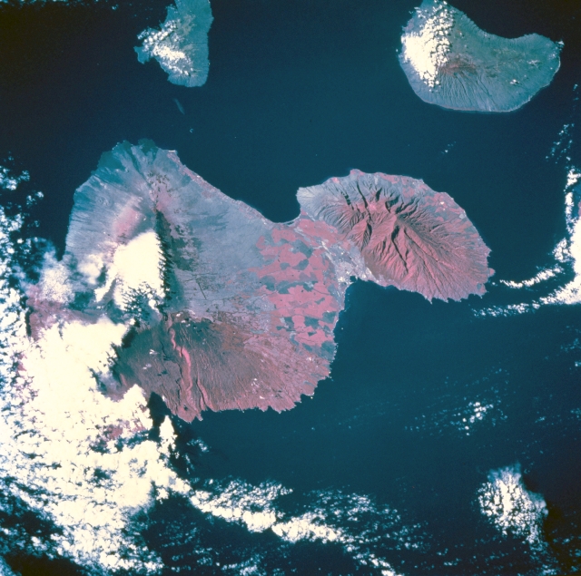 |
| STS073-745-055 Maui, Hawaii, U.S.A. October 1995 This low-oblique, westward-looking photograph of southeastern Maui features two volcanic nodes at either end of the island--Puukukui [5788 feet (1764 meters)], the major landform in western Maui, and Red Hill [10 012 feet (3052 meters)], near the center of the eastern part of the island. Infrared film (with reds representing vegetation) accentuates the drainage pattern on the slopes of these large volcanoes; e.g., the deep canyon that extends eastward from Red Hill to the ocean. Apparent is a rain shadow effect (less vegetation and less red) on the drier side of Maui. Large cultivated field patterns appear between the two volcanoes. The rapidly developing urban and tourist centers of Wailuku and Kahului are visible along the north coast of the island near the base of Puukukui. The smaller islands of Kahoolawe and Lanai, to the southwest and west, respectively, are also captured in this photograph. |
| Images: | All Available Images Low-Resolution 332k |
|
| Mission: | STS073 |
|
| Roll - Frame: | 745 - 55 |
|
| Geographical Name: | USA-HAWAII |
|
| Features: | MAUI I.,LAVA,AGR.,CITIES |
|
| Center Lat x Lon: | 21.0N x 157.5W |
|
| Film Exposure: | N | N=Normal exposure, U=Under exposed, O=Over exposed, F=out of Focus |
| Percentage of Cloud Cover-CLDP: | 25 |
|
| Camera:: | HB |
|
| Camera Tilt: | 54 | LO=Low Oblique, HO=High Oblique, NV=Near Vertical |
| Camera Focal Length: | 250 |
|
| Nadir to Photo Center Direction: | W | The direction from the nadir to the center point, N=North, S=South, E=East, W=West |
| Stereo?: | N | Y=Yes there is an adjacent picture of the same area, N=No there isn't |
| Orbit Number: | 214 |
|
| Date: | 19951102 | YYYYMMDD |
| Time: | 192508 | GMT HHMMSS |
| Nadir Lat: | 20.9N |
Latitude of suborbital point of spacecraft |
| Nadir Lon: | 154.3W |
Longitude of suborbital point of spacecraft |
| Sun Azimuth: | 130 | Clockwise angle in degrees from north to the sun measured at the nadir point |
| Space Craft Altitude: | 142 | nautical miles |
| Sun Elevation: | 38 | Angle in degrees between the horizon and the sun, measured at the nadir point |
| Land Views: | VOLCANO, MOUNTAIN |
|
| Water Views: | |
|
| Atmosphere Views: | |
|
| Man Made Views: | AGRICULTURE, URBAN AREA |
|
| City Views: | |
|
Photo is not associated with any sequences | ||
| NASA Home Page |
JSC Home Page |
JSC Digital Image Collection |
Earth Science & Remote Sensing |
|
This service is provided by the International Space Station program and the JSC Earth Science & Remote Sensing Unit, ARES Division, Exploration Integration Science Directorate.

|