Geographic Region: USA-HAWAII
Feature: OAHU I.,MTS.,CITIES,AGR.
|
Geographic Region: USA-HAWAII Feature: OAHU I.,MTS.,CITIES,AGR. |
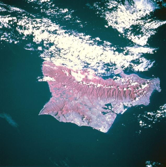 |
| STS073-745-048 Oahu, Hawaii, U.S.A. October 1995 This infrared photograph provides information about the severity of erosion on the slopes of the island's two mountain ranges. The infrared film highlights the ruggedness of both the larger Koolau Range [3150 feet (960 meters)] on the northeast and the Waianae Range [4025 feet (1227 meters)] near the southwest coast. The infrared film also helps delineate the land-water boundaries, especially around Pearl Harbor. Easily discernible is Honolulu International Airport along the south-central coast. Large green cultivated field patterns near the northwest end of the island (shown in red) indicate healthy crops are growing on large plantations. |
| Images: | All Available Images Low-Resolution 349k |
|
| Mission: | STS073 |
|
| Roll - Frame: | 745 - 48 |
|
| Geographical Name: | USA-HAWAII |
|
| Features: | OAHU I.,MTS.,CITIES,AGR. |
|
| Center Lat x Lon: | 21.5N x 158W |
|
| Film Exposure: | N | N=Normal exposure, U=Under exposed, O=Over exposed, F=out of Focus |
| Percentage of Cloud Cover-CLDP: | 35 |
|
| Camera:: | HB |
|
| Camera Tilt: | 45 | LO=Low Oblique, HO=High Oblique, NV=Near Vertical |
| Camera Focal Length: | 250 |
|
| Nadir to Photo Center Direction: | W | The direction from the nadir to the center point, N=North, S=South, E=East, W=West |
| Stereo?: | N | Y=Yes there is an adjacent picture of the same area, N=No there isn't |
| Orbit Number: | 214 |
|
| Date: | 19951102 | YYYYMMDD |
| Time: | 192443 | GMT HHMMSS |
| Nadir Lat: | 21.9N |
Latitude of suborbital point of spacecraft |
| Nadir Lon: | 155.7W |
Longitude of suborbital point of spacecraft |
| Sun Azimuth: | 129 | Clockwise angle in degrees from north to the sun measured at the nadir point |
| Space Craft Altitude: | 142 | nautical miles |
| Sun Elevation: | 36 | Angle in degrees between the horizon and the sun, measured at the nadir point |
| Land Views: | MOUNTAIN, VALLEY |
|
| Water Views: | |
|
| Atmosphere Views: | |
|
| Man Made Views: | AGRICULTURE, AIRPORT |
|
| City Views: | |
|
Photo is not associated with any sequences | ||
| NASA Home Page |
JSC Home Page |
JSC Digital Image Collection |
Earth Science & Remote Sensing |
|
This service is provided by the International Space Station program and the JSC Earth Science & Remote Sensing Unit, ARES Division, Exploration Integration Science Directorate.

|