
Geographic Region: MEXICO
Feature: USA BORDER, MTS., RES.
|
Geographic Region: MEXICO Feature: USA BORDER, MTS., RES. |
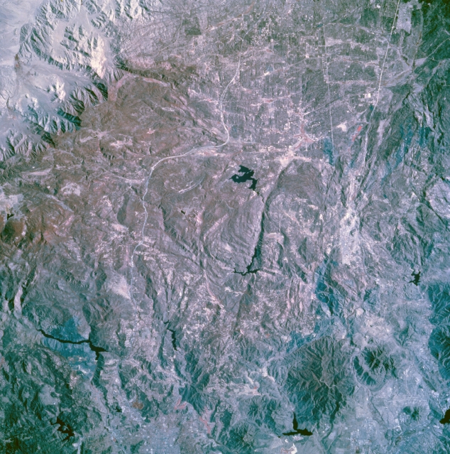 |
| STS073-744-057 Cleveland National Forest, Southern California, U.S.A. October 1995 This photograph presents several manmade features--highly reflective, east-west-oriented Interstate Highway 8, near the center of the photograph, which connects the Imperial Valley of southern California with San Diego; the east-west-oriented linear feature south of Interstate Highway 8, which is part of the U.S.-Mexico border; the black Y-shaped reservoir south of Interstate Highway 8 near the 90-degree curve; and part of Mexican Highway 2 south of the border. The darker area with a hint of red (vegetation is recorded as shades of red on color infrared film) shows some of the forested, rugged mountain terrain. Several dark, faulted valleys are discernible. |
| Images: | All Available Images Low-Resolution 400k |
|
| Mission: | STS073 |
|
| Roll - Frame: | 744 - 57 |
|
| Geographical Name: | MEXICO |
|
| Features: | USA BORDER, MTS., RES. |
|
| Center Lat x Lon: | 32.5N x 116.5W |
|
| Film Exposure: | N | N=Normal exposure, U=Under exposed, O=Over exposed, F=out of Focus |
| Percentage of Cloud Cover-CLDP: | 0 |
|
| Camera:: | HB |
|
| Camera Tilt: | 13 | LO=Low Oblique, HO=High Oblique, NV=Near Vertical |
| Camera Focal Length: | 250 |
|
| Nadir to Photo Center Direction: | SW | The direction from the nadir to the center point, N=North, S=South, E=East, W=West |
| Stereo?: | Y | Y=Yes there is an adjacent picture of the same area, N=No there isn't |
| Orbit Number: | 117 |
|
| Date: | 19951027 | YYYYMMDD |
| Time: | 182016 | GMT HHMMSS |
| Nadir Lat: | 32.9N |
Latitude of suborbital point of spacecraft |
| Nadir Lon: | 116.1W |
Longitude of suborbital point of spacecraft |
| Sun Azimuth: | 158 | Clockwise angle in degrees from north to the sun measured at the nadir point |
| Space Craft Altitude: | 144 | nautical miles |
| Sun Elevation: | 42 | Angle in degrees between the horizon and the sun, measured at the nadir point |
| Land Views: | MOUNTAIN, FAULT, FOREST |
|
| Water Views: | |
|
| Atmosphere Views: | |
|
| Man Made Views: | |
|
| City Views: | |
|
Photo is not associated with any sequences | ||
| NASA Home Page |
JSC Home Page |
JSC Digital Image Collection |
Earth Science & Remote Sensing |
|
This service is provided by the International Space Station program and the JSC Earth Science & Remote Sensing Unit, ARES Division, Exploration Integration Science Directorate.

|