
Geographic Region: USA-CALIFORNIA
Feature: SAN BERNARDINO MTS.,TAIL
|
Geographic Region: USA-CALIFORNIA Feature: SAN BERNARDINO MTS.,TAIL |
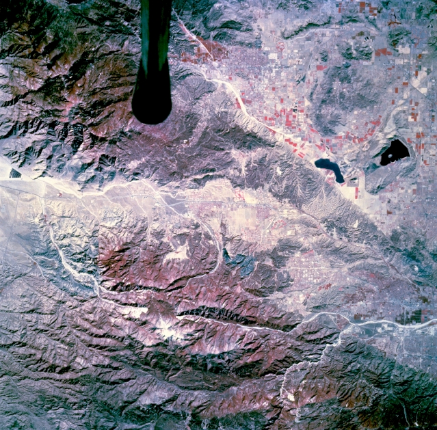 |
| STS073-744-053 San Bernardino Mountains, California, U.S.A. October 1995 Rugged mountains and urban development are featured in this photograph southeast of San Bernardino. The mountain vegetation (red) along the northern edge is part of the San Bernardino Mountains and San Bernardino National Forest. Discernible are several natural and manmade features--Lake Perris, the westernmost reservoir with a small island near its center; several prominent canyons aligned in a general east-west orientation; a short section of the Santa Ana River, a highly reflective winding narrow river valley to the northwest; and cultivated field patterns near the two reservoirs. The symmetrical dark feature is the tip of the Shuttle tail. |
| Images: | All Available Images Low-Resolution 428k |
|
| Mission: | STS073 |
|
| Roll - Frame: | 744 - 53 |
|
| Geographical Name: | USA-CALIFORNIA |
|
| Features: | SAN BERNARDINO MTS.,TAIL |
|
| Center Lat x Lon: | 34.0N x 117W |
|
| Film Exposure: | N | N=Normal exposure, U=Under exposed, O=Over exposed, F=out of Focus |
| Percentage of Cloud Cover-CLDP: | 0 |
|
| Camera:: | HB |
|
| Camera Tilt: | 17 | LO=Low Oblique, HO=High Oblique, NV=Near Vertical |
| Camera Focal Length: | 250 |
|
| Nadir to Photo Center Direction: | N | The direction from the nadir to the center point, N=North, S=South, E=East, W=West |
| Stereo?: | Y | Y=Yes there is an adjacent picture of the same area, N=No there isn't |
| Orbit Number: | 117 |
|
| Date: | 19951027 | YYYYMMDD |
| Time: | 182000 | GMT HHMMSS |
| Nadir Lat: | 33.3N |
Latitude of suborbital point of spacecraft |
| Nadir Lon: | 117.2W |
Longitude of suborbital point of spacecraft |
| Sun Azimuth: | 156 | Clockwise angle in degrees from north to the sun measured at the nadir point |
| Space Craft Altitude: | 144 | nautical miles |
| Sun Elevation: | 41 | Angle in degrees between the horizon and the sun, measured at the nadir point |
| Land Views: | MOUNTAIN, FAULT, FOREST |
|
| Water Views: | LAKE |
|
| Atmosphere Views: | |
|
| Man Made Views: | |
|
| City Views: | |
|
Photo is not associated with any sequences | ||
| NASA Home Page |
JSC Home Page |
JSC Digital Image Collection |
Earth Science & Remote Sensing |
|
This service is provided by the International Space Station program and the JSC Earth Science & Remote Sensing Unit, ARES Division, Exploration Integration Science Directorate.

|