
Geographic Region: USA-CALIFORNIA
Feature: CITIES, SAN GABRIEL MTS.
|
Geographic Region: USA-CALIFORNIA Feature: CITIES, SAN GABRIEL MTS. |
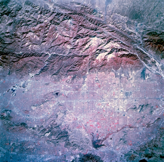 |
| STS073-744-051 Ontario, California, U.S.A. October 1995 The rugged eastern edge of the San Gabriel Mountains contrasts with the urban corridor to the south. Several major highways and the street grid patterns of Covina, Pomona, Ontario, and Fontana are evident in this color infrared photograph. Discernible is a small part of the San Andreas Fault in the northeastern quadrant. Other features include the southwest-flowing Santa Ana River (southeast side of the photograph), the Chino Hills and the Puente Hills (southwest edge of the photograph), and the tributary streams of the San Gabriel River that have cut canyons through the San Gabriel Mountains (northern part of the photograph). |
| Images: | All Available Images Low-Resolution 427k |
|
| Mission: | STS073 |
|
| Roll - Frame: | 744 - 51 |
|
| Geographical Name: | USA-CALIFORNIA |
|
| Features: | CITIES, SAN GABRIEL MTS. |
|
| Center Lat x Lon: | 34.0N x 117.5W |
|
| Film Exposure: | N | N=Normal exposure, U=Under exposed, O=Over exposed, F=out of Focus |
| Percentage of Cloud Cover-CLDP: | 0 |
|
| Camera:: | HB |
|
| Camera Tilt: | 14 | LO=Low Oblique, HO=High Oblique, NV=Near Vertical |
| Camera Focal Length: | 250 |
|
| Nadir to Photo Center Direction: | N | The direction from the nadir to the center point, N=North, S=South, E=East, W=West |
| Stereo?: | Y | Y=Yes there is an adjacent picture of the same area, N=No there isn't |
| Orbit Number: | 117 |
|
| Date: | 19951027 | YYYYMMDD |
| Time: | 181955 | GMT HHMMSS |
| Nadir Lat: | 33.4N |
Latitude of suborbital point of spacecraft |
| Nadir Lon: | 117.5W |
Longitude of suborbital point of spacecraft |
| Sun Azimuth: | 156 | Clockwise angle in degrees from north to the sun measured at the nadir point |
| Space Craft Altitude: | 144 | nautical miles |
| Sun Elevation: | 41 | Angle in degrees between the horizon and the sun, measured at the nadir point |
| Land Views: | MOUNTAIN, FAULT, VALLEY |
|
| Water Views: | |
|
| Atmosphere Views: | |
|
| Man Made Views: | URBAN AREA |
|
| City Views: | ONTARIO |
|
Photo is not associated with any sequences | ||
| NASA Home Page |
JSC Home Page |
JSC Digital Image Collection |
Earth Science & Remote Sensing |
|
This service is provided by the International Space Station program and the JSC Earth Science & Remote Sensing Unit, ARES Division, Exploration Integration Science Directorate.

|