
Geographic Region: USA-CALIFORNIA
Feature: LOS ANGELES AREA, COAST
|
Geographic Region: USA-CALIFORNIA Feature: LOS ANGELES AREA, COAST |
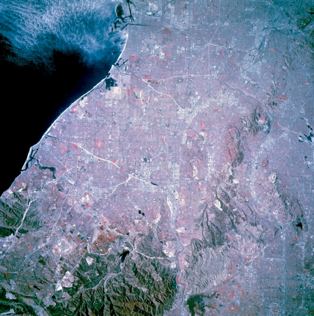 |
| STS073-744-050 Southern Metropolitan Los Angeles, California, U.S.A. October 1995 This photograph, except for the hilly regions in the southeastern quadrant, Chino Hills, and Puente Hills, features one of the world's most densely populated urban areas. Many of the larger commercial and industrial complexes of southeastern metropolitan Los Angeles can be identified by their highly reflective surfaces (concrete and steel). By contrast, the isolated reddish areas map parks and golf courses. Many of the white, highly reflective linear features are combinations of river courses (concrete aqueducts) and the major freeways that parallel them--the Santa Ana, San Gabriel, and Los Angeles Rivers have accompanying freeways (Riverside, San Gabriel, and Long Beach, respectively). Visible are two major harbor facilities along the Long Beach coast and a vast street grid pattern that characterizes this dynamic region. |
| Images: | All Available Images Low-Resolution 387k |
|
| Mission: | STS073 |
|
| Roll - Frame: | 744 - 50 |
|
| Geographical Name: | USA-CALIFORNIA |
|
| Features: | LOS ANGELES AREA, COAST |
|
| Center Lat x Lon: | 34.0N x 118W |
|
| Film Exposure: | N | N=Normal exposure, U=Under exposed, O=Over exposed, F=out of Focus |
| Percentage of Cloud Cover-CLDP: | 0 |
|
| Camera:: | HB |
|
| Camera Tilt: | 13 | LO=Low Oblique, HO=High Oblique, NV=Near Vertical |
| Camera Focal Length: | 250 |
|
| Nadir to Photo Center Direction: | N | The direction from the nadir to the center point, N=North, S=South, E=East, W=West |
| Stereo?: | Y | Y=Yes there is an adjacent picture of the same area, N=No there isn't |
| Orbit Number: | 117 |
|
| Date: | 19951027 | YYYYMMDD |
| Time: | 181951 | GMT HHMMSS |
| Nadir Lat: | 33.5N |
Latitude of suborbital point of spacecraft |
| Nadir Lon: | 117.8W |
Longitude of suborbital point of spacecraft |
| Sun Azimuth: | 156 | Clockwise angle in degrees from north to the sun measured at the nadir point |
| Space Craft Altitude: | 144 | nautical miles |
| Sun Elevation: | 40 | Angle in degrees between the horizon and the sun, measured at the nadir point |
| Land Views: | COAST, FAULT |
|
| Water Views: | |
|
| Atmosphere Views: | |
|
| Man Made Views: | URBAN AREA |
|
| City Views: | LOS ANGELES |
|
Photo is not associated with any sequences | ||
| NASA Home Page |
JSC Home Page |
JSC Digital Image Collection |
Earth Science & Remote Sensing |
|
This service is provided by the International Space Station program and the JSC Earth Science & Remote Sensing Unit, ARES Division, Exploration Integration Science Directorate.

|