
Geographic Region: USA-CALIFORNIA
Feature: LOS ANGELES, COAST
|
Geographic Region: USA-CALIFORNIA Feature: LOS ANGELES, COAST |
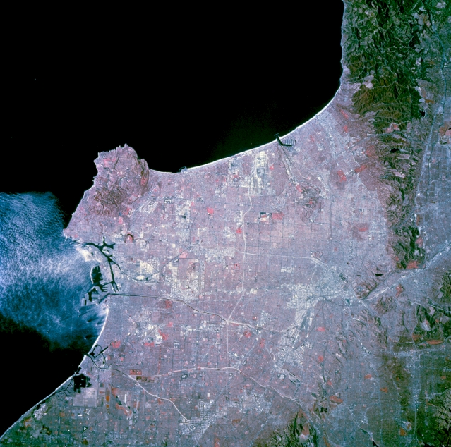 |
| STS073-744-049 Central Los Angeles, California, U.S.A. November 1995 The network of freeways that crisscrosses metropolitan Los Angeles is captured in this near-vertical, color infrared photograph. Several major freeways--Long Beach, San Gabriel River, and Riverside--are immediately adjacent to and parallel with the major rivers that drain the basin. This relationship of freeway and river enhances the detectability of these corridors as highly reflective, white lines. The dark lines are either part of the road network or water channels for agriculture. Scattered industrial and commercial features appear as highly reflective, larger spatial areas. The central business district is visible. The east-west-oriented runways of Los Angeles International Airport are discernible midway between the Palos Verdes Hills and the Santa Monica Mountains adjacent to Santa Monica Bay. Two major port facilities lie east of the Palos Verdes Peninsula. Color infrared film displays green vegetation (parks, college campuses, or golf courses) as reds in the photograph. |
| Images: | All Available Images Low-Resolution 305k |
|
| Mission: | STS073 |
|
| Roll - Frame: | 744 - 49 |
|
| Geographical Name: | USA-CALIFORNIA |
|
| Features: | LOS ANGELES, COAST |
|
| Center Lat x Lon: | 34.0N x 118.5W |
|
| Film Exposure: | N | N=Normal exposure, U=Under exposed, O=Over exposed, F=out of Focus |
| Percentage of Cloud Cover-CLDP: | 0 |
|
| Camera:: | HB |
|
| Camera Tilt: | 13 | LO=Low Oblique, HO=High Oblique, NV=Near Vertical |
| Camera Focal Length: | 250 |
|
| Nadir to Photo Center Direction: | NW | The direction from the nadir to the center point, N=North, S=South, E=East, W=West |
| Stereo?: | Y | Y=Yes there is an adjacent picture of the same area, N=No there isn't |
| Orbit Number: | 117 |
|
| Date: | 19951027 | YYYYMMDD |
| Time: | 181947 | GMT HHMMSS |
| Nadir Lat: | 33.6N |
Latitude of suborbital point of spacecraft |
| Nadir Lon: | 118.1W |
Longitude of suborbital point of spacecraft |
| Sun Azimuth: | 155 | Clockwise angle in degrees from north to the sun measured at the nadir point |
| Space Craft Altitude: | 144 | nautical miles |
| Sun Elevation: | 40 | Angle in degrees between the horizon and the sun, measured at the nadir point |
| Land Views: | COAST, BASIN |
|
| Water Views: | |
|
| Atmosphere Views: | |
|
| Man Made Views: | URBAN AREA |
|
| City Views: | LOS ANGELES |
|
Photo is not associated with any sequences | ||
| NASA Home Page |
JSC Home Page |
JSC Digital Image Collection |
Earth Science & Remote Sensing |
|
This service is provided by the International Space Station program and the JSC Earth Science & Remote Sensing Unit, ARES Division, Exploration Integration Science Directorate.

|