
Geographic Region: USA-CALIFORNIA
Feature: SAN FERNANDO VALLEY,CITY
|
Geographic Region: USA-CALIFORNIA Feature: SAN FERNANDO VALLEY,CITY |
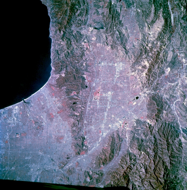 |
| STS073-744-048 Northwestern Los Angeles Basin, California, U.S.A. November 1995 Four mountain ranges are discernible in this color infrared, near-vertical photograph of the northwest part of the greater Los Angeles metropolitan area--the Santa Monica Mountains that form the southern boundary of the San Fernando Valley and lie west of Los Angeles; the Santa Susana Mountains on the northwest side of the valley; the San Gabriel Mountains east of the Santa Susanas; and the Verdugo Mountains, a much smaller range sandwiched between the eastern end of the Santa Monica Mountains and the San Gabriel Mountains. Apparent are the ground transportation corridors--U.S. Highway 101, Interstate Highway 5, and Interstate Highway 210 that connect the San Fernando Valley with the much larger Los Angeles Basin. Visible are Van Norman Reservoir west of Interstate Highway 5; the east-west runways of the Los Angeles International Airport; Marina del Rey northwest of the airport; and some of the gridded street network of downtown Los Angeles near the junction of Interstate Highway 5, U.S. Highway 101, and the Los Angeles River. The large red areas of vegetation are probably parks or golf courses. |
| Images: | All Available Images Low-Resolution 371k |
|
| Mission: | STS073 |
|
| Roll - Frame: | 744 - 48 |
|
| Geographical Name: | USA-CALIFORNIA |
|
| Features: | SAN FERNANDO VALLEY,CITY |
|
| Center Lat x Lon: | 34.0N x 118.5W |
|
| Film Exposure: | N | N=Normal exposure, U=Under exposed, O=Over exposed, F=out of Focus |
| Percentage of Cloud Cover-CLDP: | 0 |
|
| Camera:: | HB |
|
| Camera Tilt: | 5 | LO=Low Oblique, HO=High Oblique, NV=Near Vertical |
| Camera Focal Length: | 250 |
|
| Nadir to Photo Center Direction: | N | The direction from the nadir to the center point, N=North, S=South, E=East, W=West |
| Stereo?: | Y | Y=Yes there is an adjacent picture of the same area, N=No there isn't |
| Orbit Number: | 117 |
|
| Date: | 19951027 | YYYYMMDD |
| Time: | 181941 | GMT HHMMSS |
| Nadir Lat: | 33.8N |
Latitude of suborbital point of spacecraft |
| Nadir Lon: | 118.5W |
Longitude of suborbital point of spacecraft |
| Sun Azimuth: | 155 | Clockwise angle in degrees from north to the sun measured at the nadir point |
| Space Craft Altitude: | 144 | nautical miles |
| Sun Elevation: | 40 | Angle in degrees between the horizon and the sun, measured at the nadir point |
| Land Views: | MOUNTAIN, FAULT, VALLEY |
|
| Water Views: | |
|
| Atmosphere Views: | |
|
| Man Made Views: | URBAN AREA |
|
| City Views: | LOS ANGELES |
|
Photo is not associated with any sequences | ||
| NASA Home Page |
JSC Home Page |
JSC Digital Image Collection |
Earth Science & Remote Sensing |
|
This service is provided by the International Space Station program and the JSC Earth Science & Remote Sensing Unit, ARES Division, Exploration Integration Science Directorate.

|