
Geographic Region: USA-CALIFORNIA
Feature: MTS., RES.,SANTA BARBARA
|
Geographic Region: USA-CALIFORNIA Feature: MTS., RES.,SANTA BARBARA |
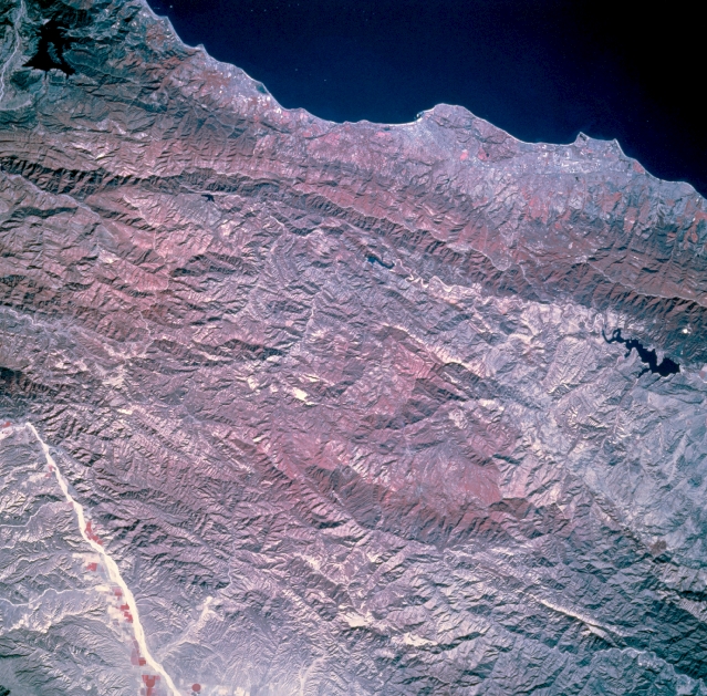 |
| STS073-744-046 Santa Barbara, California, U.S.A. November 1995 The low Santa Ynez Mountains, a linear concentration of reds (an indication of dense vegetation), parallel this part of the California coastline. The higher elevations of the San Rafael Mountains farther north reflect more dense vegetation than some of the lower elevation valley areas. The east-west-trending white line is a road that follows the main ridgeline of the Santa Ynez Mountains. Lake Cachuma is the black irregular feature near the western edge of the photograph. Although the infrastructure for Santa Barbara is not discernible, the city and Goleta are included in this photograph. The highly reflective, linear feature to the northeast is part of a dry lakebed along a narrow valley. |
| Images: | All Available Images Low-Resolution 399k |
|
| Mission: | STS073 |
|
| Roll - Frame: | 744 - 46 |
|
| Geographical Name: | USA-CALIFORNIA |
|
| Features: | MTS., RES.,SANTA BARBARA |
|
| Center Lat x Lon: | 34.5N x 119.5W |
|
| Film Exposure: | N | N=Normal exposure, U=Under exposed, O=Over exposed, F=out of Focus |
| Percentage of Cloud Cover-CLDP: | 0 |
|
| Camera:: | HB |
|
| Camera Tilt: | 9 | LO=Low Oblique, HO=High Oblique, NV=Near Vertical |
| Camera Focal Length: | 250 |
|
| Nadir to Photo Center Direction: | N | The direction from the nadir to the center point, N=North, S=South, E=East, W=West |
| Stereo?: | Y | Y=Yes there is an adjacent picture of the same area, N=No there isn't |
| Orbit Number: | 117 |
|
| Date: | 19951027 | YYYYMMDD |
| Time: | 181927 | GMT HHMMSS |
| Nadir Lat: | 34.1N |
Latitude of suborbital point of spacecraft |
| Nadir Lon: | 119.5W |
Longitude of suborbital point of spacecraft |
| Sun Azimuth: | 154 | Clockwise angle in degrees from north to the sun measured at the nadir point |
| Space Craft Altitude: | 144 | nautical miles |
| Sun Elevation: | 39 | Angle in degrees between the horizon and the sun, measured at the nadir point |
| Land Views: | COAST, MOUNTAIN, FAULT, FOREST |
|
| Water Views: | LAKE |
|
| Atmosphere Views: | |
|
| Man Made Views: | |
|
| City Views: | |
|
Photo is not associated with any sequences | ||
| NASA Home Page |
JSC Home Page |
JSC Digital Image Collection |
Earth Science & Remote Sensing |
|
This service is provided by the International Space Station program and the JSC Earth Science & Remote Sensing Unit, ARES Division, Exploration Integration Science Directorate.

|