
Geographic Region: USA-MISSOURI
Feature: ST. LOUIS,MS & MO RIVERS
|
Geographic Region: USA-MISSOURI Feature: ST. LOUIS,MS & MO RIVERS |
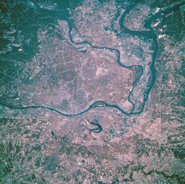 |
| STS073-743-005 Saint Louis, Missouri, U.S.A. October 1995 This color infrared photograph features metropolitan Saint Louis, the "Gateway to the West," the starting point for early explorers and settlers to the western United States. Saint Louis, the largest city in Missouri, is a great river freight handling center; a major rail center; and a wholesale, banking, financial, and industrial center. The Missouri River flows east-northeast and joins the Mississippi River north of Saint Louis, which lies south of the confluence of the Illinois and Mississippi Rivers. East of the Mississippi River and north of East Saint Louis is Horseshoe Lake. The runways of Lambert-Saint Louis International Airport are discernible northwest of downtown. |
| Images: | All Available Images Low-Resolution 406k |
|
| Mission: | STS073 |
|
| Roll - Frame: | 743 - 5 |
|
| Geographical Name: | USA-MISSOURI |
|
| Features: | ST. LOUIS,MS & MO RIVERS |
|
| Center Lat x Lon: | 38.5N x 90.5W |
|
| Film Exposure: | N | N=Normal exposure, U=Under exposed, O=Over exposed, F=out of Focus |
| Percentage of Cloud Cover-CLDP: | 0 |
|
| Camera:: | HB |
|
| Camera Tilt: | 35 | LO=Low Oblique, HO=High Oblique, NV=Near Vertical |
| Camera Focal Length: | 250 |
|
| Nadir to Photo Center Direction: | W | The direction from the nadir to the center point, N=North, S=South, E=East, W=West |
| Stereo?: | N | Y=Yes there is an adjacent picture of the same area, N=No there isn't |
| Orbit Number: | 50 |
|
| Date: | 19951023 | YYYYMMDD |
| Time: | 152654 | GMT HHMMSS |
| Nadir Lat: | 38.7N |
Latitude of suborbital point of spacecraft |
| Nadir Lon: | 88.8W |
Longitude of suborbital point of spacecraft |
| Sun Azimuth: | 141 | Clockwise angle in degrees from north to the sun measured at the nadir point |
| Space Craft Altitude: | 145 | nautical miles |
| Sun Elevation: | 31 | Angle in degrees between the horizon and the sun, measured at the nadir point |
| Land Views: | VALLEY |
|
| Water Views: | RIVER |
|
| Atmosphere Views: | |
|
| Man Made Views: | URBAN AREA, AIRPORT, AGRICULTURE |
|
| City Views: | ST. LOUIS, EAST ST. LOUIS |
|
Photo is not associated with any sequences | ||
| NASA Home Page |
JSC Home Page |
JSC Digital Image Collection |
Earth Science & Remote Sensing |
|
This service is provided by the International Space Station program and the JSC Earth Science & Remote Sensing Unit, ARES Division, Exploration Integration Science Directorate.

|