
Geographic Region: USA-NEW JERSEY
Feature: COAST,FOR.,ATLANTIC CITY
|
Geographic Region: USA-NEW JERSEY Feature: COAST,FOR.,ATLANTIC CITY |
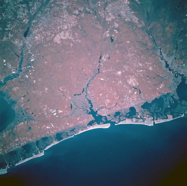 |
| STS073-741-067 Atlantic City Area, New Jersey, U.S.A. October 1995 This is a color infrared image of the Atlantic City area in coastal, southeast New Jersey. The bright red area that dominates the scene is a sizable region of elevated forested land. This densely wooded area is interrupted by three major drainage features in this scene: the Maurice River that flows southward into Delaware Bay (left), the Great Egg Harbor River (darker drainage in the middle of the picture), and the Mullica River (dark, winding feature along the right edge of the image). The sharp linear boundary that extends northeast-southwest across the scene along the coast is a physiographic boundary between the coastal barrier beach-lagoon landscape and the forested uplands. The darker red region just inland from the brighter sandy beach is the marsh vegetation in the coastal lagoons. The sandy beaches of southeast New Jersey have been a major tourist attraction for almost 100 years. The general location of Atlantic City can be identified near the right middle edge of the image where a broad section of the beach extends into the Atlantic Ocean. |
| Images: | All Available Images Low-Resolution 329k |
|
| Mission: | STS073 |
|
| Roll - Frame: | 741 - 67 |
|
| Geographical Name: | USA-NEW JERSEY |
|
| Features: | COAST,FOR.,ATLANTIC CITY |
|
| Center Lat x Lon: | 39.5N x 74.5W |
|
| Film Exposure: | N | N=Normal exposure, U=Under exposed, O=Over exposed, F=out of Focus |
| Percentage of Cloud Cover-CLDP: | 0 |
|
| Camera:: | HB |
|
| Camera Tilt: | 24 | LO=Low Oblique, HO=High Oblique, NV=Near Vertical |
| Camera Focal Length: | 250 |
|
| Nadir to Photo Center Direction: | NW | The direction from the nadir to the center point, N=North, S=South, E=East, W=West |
| Stereo?: | N | Y=Yes there is an adjacent picture of the same area, N=No there isn't |
| Orbit Number: | 65 |
|
| Date: | 19951024 | YYYYMMDD |
| Time: | 135317 | GMT HHMMSS |
| Nadir Lat: | 38.6N |
Latitude of suborbital point of spacecraft |
| Nadir Lon: | 73.9W |
Longitude of suborbital point of spacecraft |
| Sun Azimuth: | 133 | Clockwise angle in degrees from north to the sun measured at the nadir point |
| Space Craft Altitude: | 144 | nautical miles |
| Sun Elevation: | 27 | Angle in degrees between the horizon and the sun, measured at the nadir point |
| Land Views: | |
|
| Water Views: | RIVER, OCEAN, LAGOON |
|
| Atmosphere Views: | |
|
| Man Made Views: | |
|
| City Views: | ATLANTIC CITY |
|
Photo is not associated with any sequences | ||
| NASA Home Page |
JSC Home Page |
JSC Digital Image Collection |
Earth Science & Remote Sensing |
|
This service is provided by the International Space Station program and the JSC Earth Science & Remote Sensing Unit, ARES Division, Exploration Integration Science Directorate.

|