
Geographic Region: USA-MARYLAND
Feature: DE RIVER,AGR.,WILMINGTON
|
Geographic Region: USA-MARYLAND Feature: DE RIVER,AGR.,WILMINGTON |
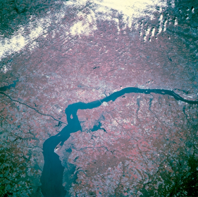 |
| STS073-741-065 Wilmington Area, Delaware, U.S.A. October 1995 Wilmington, the largest city in Delaware, is on the northwest side of the Delaware River, just north of the bridge in the center of the picture (view to northwest). The Interstate Highway 295 bridge (Delaware Memorial Bridge) connects the Wilmington area with the New Jersey Turnpike on the east side of the Delaware River. Sections of Interstate Highway 95 (linear, light colored feature) also helps to identify the location of Wilmington. The thin, dark, east-west oriented feature (left center) is the Chesapeake and Delaware Canal, which connects the northern end of Chesapeake Bay with the Delaware River. Areas of deep red on this image are forested and lighter reds correspond to lands used for agriculture. The darker landscapes (lower left) along the Delaware River shoreline are marshy wetlands. The linear, light-colored feature (far right center) is the runway at Philadelphia International Airport. |
| Images: | All Available Images Low-Resolution 400k |
|
| Mission: | STS073 |
|
| Roll - Frame: | 741 - 65 |
|
| Geographical Name: | USA-MARYLAND |
|
| Features: | DE RIVER,AGR.,WILMINGTON |
|
| Center Lat x Lon: | 39.5N x 75.5W |
|
| Film Exposure: | N | N=Normal exposure, U=Under exposed, O=Over exposed, F=out of Focus |
| Percentage of Cloud Cover-CLDP: | 15 |
|
| Camera:: | HB |
|
| Camera Tilt: | 28 | LO=Low Oblique, HO=High Oblique, NV=Near Vertical |
| Camera Focal Length: | 250 |
|
| Nadir to Photo Center Direction: | NW | The direction from the nadir to the center point, N=North, S=South, E=East, W=West |
| Stereo?: | Y | Y=Yes there is an adjacent picture of the same area, N=No there isn't |
| Orbit Number: | 65 |
|
| Date: | 19951024 | YYYYMMDD |
| Time: | 135307 | GMT HHMMSS |
| Nadir Lat: | 38.5N |
Latitude of suborbital point of spacecraft |
| Nadir Lon: | 74.7W |
Longitude of suborbital point of spacecraft |
| Sun Azimuth: | 133 | Clockwise angle in degrees from north to the sun measured at the nadir point |
| Space Craft Altitude: | 144 | nautical miles |
| Sun Elevation: | 26 | Angle in degrees between the horizon and the sun, measured at the nadir point |
| Land Views: | PLAIN |
|
| Water Views: | RIVER, CANAL |
|
| Atmosphere Views: | |
|
| Man Made Views: | AGRICULTURE, HIGHWAY |
|
| City Views: | |
|
Photo is not associated with any sequences | ||
| NASA Home Page |
JSC Home Page |
JSC Digital Image Collection |
Earth Science & Remote Sensing |
|
This service is provided by the International Space Station program and the JSC Earth Science & Remote Sensing Unit, ARES Division, Exploration Integration Science Directorate.

|