
Geographic Region: USA-MARYLAND
Feature: CHESAPEAKE BAY,AGR.,CITY
|
Geographic Region: USA-MARYLAND Feature: CHESAPEAKE BAY,AGR.,CITY |
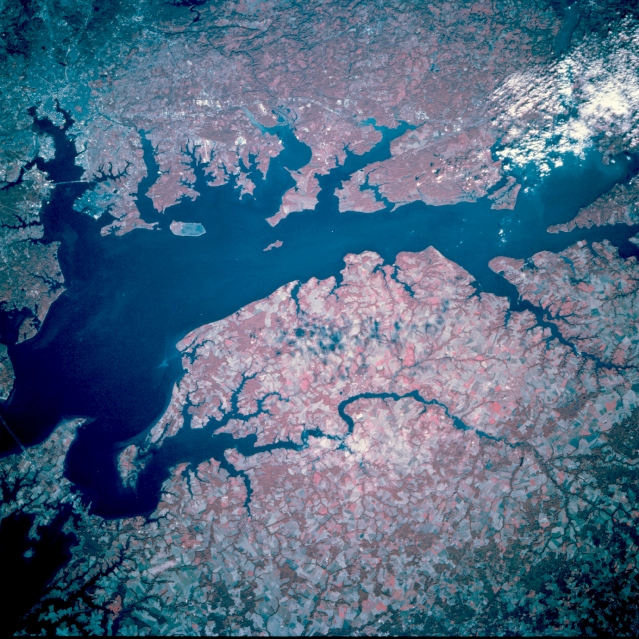 |
| STS073-741-064 Upper Chesapeake Bay, Maryland, U.S.A. October 1995 Clouds cover the mouth of the Susquehanna River in Chesapeake Bay in this north-northwest-looking, low-oblique, color-infrared view. Chesapeake Bay, the largest estuary in the United States, is the drowned river valley of the Susquehanna River, which originally flowed into the Atlantic Ocean east of present-day Norfolk, Virginia. Ice Age (Pleistocene) glaciers retreated nearly 10000 years ago; as the ice melted sea level rose and the original channel was drowned. The city of Baltimore and the bridge over the Petapsco River are discernible in the upper left portion of the image. On Delmarva Peninsula (lower half of image) the Chester River flows westward and empties into Chesapeake Bay just north of Kent Island (bottom left). Agricultural fields on Delmarva Peninsula are visible as paler red patches, contrasting with dark red forested areas. |
| Images: | All Available Images Low-Resolution 400k |
|
| Mission: | STS073 |
|
| Roll - Frame: | 741 - 64 |
|
| Geographical Name: | USA-MARYLAND |
|
| Features: | CHESAPEAKE BAY,AGR.,CITY |
|
| Center Lat x Lon: | 39.5N x 76W |
|
| Film Exposure: | N | N=Normal exposure, U=Under exposed, O=Over exposed, F=out of Focus |
| Percentage of Cloud Cover-CLDP: | 10 |
|
| Camera:: | HB |
|
| Camera Tilt: | 31 | LO=Low Oblique, HO=High Oblique, NV=Near Vertical |
| Camera Focal Length: | 250 |
|
| Nadir to Photo Center Direction: | NW | The direction from the nadir to the center point, N=North, S=South, E=East, W=West |
| Stereo?: | Y | Y=Yes there is an adjacent picture of the same area, N=No there isn't |
| Orbit Number: | 65 |
|
| Date: | 19951024 | YYYYMMDD |
| Time: | 135302 | GMT HHMMSS |
| Nadir Lat: | 38.4N |
Latitude of suborbital point of spacecraft |
| Nadir Lon: | 75.1W |
Longitude of suborbital point of spacecraft |
| Sun Azimuth: | 132 | Clockwise angle in degrees from north to the sun measured at the nadir point |
| Space Craft Altitude: | 144 | nautical miles |
| Sun Elevation: | 26 | Angle in degrees between the horizon and the sun, measured at the nadir point |
| Land Views: | PLAIN |
|
| Water Views: | BAY, ESTUARY |
|
| Atmosphere Views: | |
|
| Man Made Views: | AGRICULTURE |
|
| City Views: | |
|
Photo is not associated with any sequences | ||
| NASA Home Page |
JSC Home Page |
JSC Digital Image Collection |
Earth Science & Remote Sensing |
|
This service is provided by the International Space Station program and the JSC Earth Science & Remote Sensing Unit, ARES Division, Exploration Integration Science Directorate.

|