
Geographic Region: USA-MARYLAND
Feature: CHESAPEAKE BAY,BALTIMORE
|
Geographic Region: USA-MARYLAND Feature: CHESAPEAKE BAY,BALTIMORE |
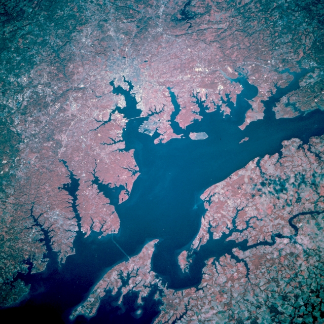 |
| STS073-741-063 Chesapeake Bay; Baltimore, Maryland, U.S.A. October 1995 The largest city in Maryland, Baltimore, is near the center of this north-northwest-looking, low-oblique, color-infrared view. Chesapeake Bay extends from right center (northeast) to bottom-left (south). The gently rolling, forested terrain west of Chesapeake Bay (dark red) contrasts with the flatter, mostly agricultural lands of the Delmarva Peninsula (paler shades of red, lower right), east of Chesapeake Bay. Situated on the Patapsco River estuary, Baltimore is a major shipping and receiving center for coal, grain, iron steel, and copper. Principal industries include steel mills, shipbuilding, oil refining, chemical production, and manufacture of aerospace equipment. Baltimore is the home of Johns Hopkins University, one of the leading medical and public health universities in the world. In the War of 1812 against the British, the gallant defense of Fort McHenry inspired Francis Scott Key to write the Star Spangled Banner, which became the national anthem for the United States. The ship USS Constellation, a national historic shrine, is also docked here. |
| Images: | All Available Images Low-Resolution 393k |
|
| Mission: | STS073 |
|
| Roll - Frame: | 741 - 63 |
|
| Geographical Name: | USA-MARYLAND |
|
| Features: | CHESAPEAKE BAY,BALTIMORE |
|
| Center Lat x Lon: | 39.0N x 76.5W |
|
| Film Exposure: | N | N=Normal exposure, U=Under exposed, O=Over exposed, F=out of Focus |
| Percentage of Cloud Cover-CLDP: | 0 |
|
| Camera:: | HB |
|
| Camera Tilt: | 28 | LO=Low Oblique, HO=High Oblique, NV=Near Vertical |
| Camera Focal Length: | 250 |
|
| Nadir to Photo Center Direction: | NW | The direction from the nadir to the center point, N=North, S=South, E=East, W=West |
| Stereo?: | Y | Y=Yes there is an adjacent picture of the same area, N=No there isn't |
| Orbit Number: | 65 |
|
| Date: | 19951024 | YYYYMMDD |
| Time: | 135259 | GMT HHMMSS |
| Nadir Lat: | 38.4N |
Latitude of suborbital point of spacecraft |
| Nadir Lon: | 75.4W |
Longitude of suborbital point of spacecraft |
| Sun Azimuth: | 132 | Clockwise angle in degrees from north to the sun measured at the nadir point |
| Space Craft Altitude: | 144 | nautical miles |
| Sun Elevation: | 26 | Angle in degrees between the horizon and the sun, measured at the nadir point |
| Land Views: | FOREST |
|
| Water Views: | BAY, ESTUARY |
|
| Atmosphere Views: | |
|
| Man Made Views: | URBAN AREA, AGRICULTURE |
|
| City Views: | BALTIMORE |
|
Photo is not associated with any sequences | ||
| NASA Home Page |
JSC Home Page |
JSC Digital Image Collection |
Earth Science & Remote Sensing |
|
This service is provided by the International Space Station program and the JSC Earth Science & Remote Sensing Unit, ARES Division, Exploration Integration Science Directorate.

|