
Geographic Region: USA-MARYLAND
Feature: POTOMAC RIVER, DC AREA
|
Geographic Region: USA-MARYLAND Feature: POTOMAC RIVER, DC AREA |
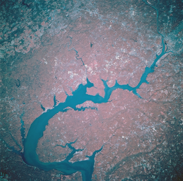 |
| STS073-741-060 The Potomac River, Maryland/Virginia, U.S.A. October 1995 Flanked by the state of Virginia to the west (top of image), and the state of Maryland to the east (bottom of image), the Potomac River can be seen in this northwest-looking low-oblique color-infrared view. The terrain in this region is gently rolling, with forest cover (deep red on the infrared view) and patches of cleared or pasture land (paler shades of red). The headwaters of the Potomac are near Cumberland, Maryland, and the stream flows generally southeast for 285 miles (459 km). The river has cut several gaps across the parallel ridges of the Appalachian Mountains. The river enters the scene near Great Falls (upper right), passes through the Washington, D.C., area, and enters the tidal estuary south of the city as it flows toward Chesapeake Bay. |
| Images: | All Available Images Low-Resolution 375k |
|
| Mission: | STS073 |
|
| Roll - Frame: | 741 - 60 |
|
| Geographical Name: | USA-MARYLAND |
|
| Features: | POTOMAC RIVER, DC AREA |
|
| Center Lat x Lon: | 38.5N x 77W |
|
| Film Exposure: | N | N=Normal exposure, U=Under exposed, O=Over exposed, F=out of Focus |
| Percentage of Cloud Cover-CLDP: | 0 |
|
| Camera:: | HB |
|
| Camera Tilt: | 19 | LO=Low Oblique, HO=High Oblique, NV=Near Vertical |
| Camera Focal Length: | 250 |
|
| Nadir to Photo Center Direction: | W | The direction from the nadir to the center point, N=North, S=South, E=East, W=West |
| Stereo?: | Y | Y=Yes there is an adjacent picture of the same area, N=No there isn't |
| Orbit Number: | 65 |
|
| Date: | 19951024 | YYYYMMDD |
| Time: | 135249 | GMT HHMMSS |
| Nadir Lat: | 38.3N |
Latitude of suborbital point of spacecraft |
| Nadir Lon: | 76.2W |
Longitude of suborbital point of spacecraft |
| Sun Azimuth: | 131 | Clockwise angle in degrees from north to the sun measured at the nadir point |
| Space Craft Altitude: | 144 | nautical miles |
| Sun Elevation: | 25 | Angle in degrees between the horizon and the sun, measured at the nadir point |
| Land Views: | PLAIN, FOREST |
|
| Water Views: | RIVER, ESTUARY |
|
| Atmosphere Views: | |
|
| Man Made Views: | |
|
| City Views: | |
|
Photo is not associated with any sequences | ||
| NASA Home Page |
JSC Home Page |
JSC Digital Image Collection |
Earth Science & Remote Sensing |
|
This service is provided by the International Space Station program and the JSC Earth Science & Remote Sensing Unit, ARES Division, Exploration Integration Science Directorate.

|