
Geographic Region: USA-OKLAHOMA
Feature: TULSA, ARKANSAS R., AGR.
|
Geographic Region: USA-OKLAHOMA Feature: TULSA, ARKANSAS R., AGR. |
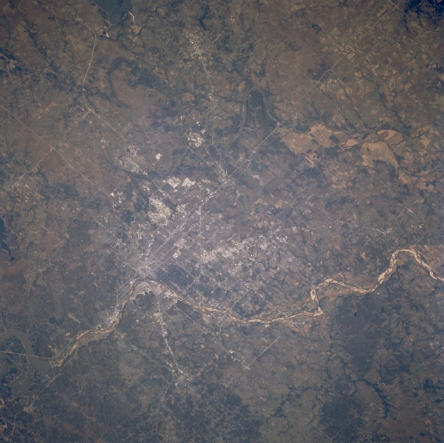 |
| STS073-731-080 Tulsa and Arkansas River, Oklahoma, U.S.A. October 1995 Tulsa, the second largest city in Oklahoma, is obvious in this northeast-looking, low-oblique photograph. A principal financial, commercial, and transportation center in a major oil producing region, Tulsa is also the home of some of the best medical facilities in the United States. Important to the city's economy are aircraft and aircraft components, electronic components, oil field equipment, machinery, cement, glass, canned goods, gas and oil wells, oil refineries, and coal mining. Tulsa became an inland port with the opening in 1971 of the McClellan-Kerr Waterway, a 440-mile (708-kilometer) system linking the city with the Mississippi River and the Gulf of Mexico. Visible is the Arkansas River as it leaves Keystone Lake and flows southeast past Tulsa. |
| Images: | All Available Images Low-Resolution 329k |
|
| Mission: | STS073 |
|
| Roll - Frame: | 731 - 80 |
|
| Geographical Name: | USA-OKLAHOMA |
|
| Features: | TULSA, ARKANSAS R., AGR. |
|
| Center Lat x Lon: | 36.0N x 96W |
|
| Film Exposure: | N | N=Normal exposure, U=Under exposed, O=Over exposed, F=out of Focus |
| Percentage of Cloud Cover-CLDP: | 0 |
|
| Camera:: | HB |
|
| Camera Tilt: | 36 | LO=Low Oblique, HO=High Oblique, NV=Near Vertical |
| Camera Focal Length: | 250 |
|
| Nadir to Photo Center Direction: | SW | The direction from the nadir to the center point, N=North, S=South, E=East, W=West |
| Stereo?: | N | Y=Yes there is an adjacent picture of the same area, N=No there isn't |
| Orbit Number: | 34 |
|
| Date: | 19951022 | YYYYMMDD |
| Time: | 152730 | GMT HHMMSS |
| Nadir Lat: | 36.8N |
Latitude of suborbital point of spacecraft |
| Nadir Lon: | 94.4W |
Longitude of suborbital point of spacecraft |
| Sun Azimuth: | 135 | Clockwise angle in degrees from north to the sun measured at the nadir point |
| Space Craft Altitude: | 146 | nautical miles |
| Sun Elevation: | 30 | Angle in degrees between the horizon and the sun, measured at the nadir point |
| Land Views: | PLAIN |
|
| Water Views: | RIVER |
|
| Atmosphere Views: | |
|
| Man Made Views: | URBAN AREA |
|
| City Views: | TULSA |
|
Photo is not associated with any sequences | ||
| NASA Home Page |
JSC Home Page |
JSC Digital Image Collection |
Earth Science & Remote Sensing |
|
This service is provided by the International Space Station program and the JSC Earth Science & Remote Sensing Unit, ARES Division, Exploration Integration Science Directorate.

|