
Geographic Region: USA-LOUISIANA
Feature: RED RIVER, AGRICULTURE, RES.
|
Geographic Region: USA-LOUISIANA Feature: RED RIVER, AGRICULTURE, RES. |
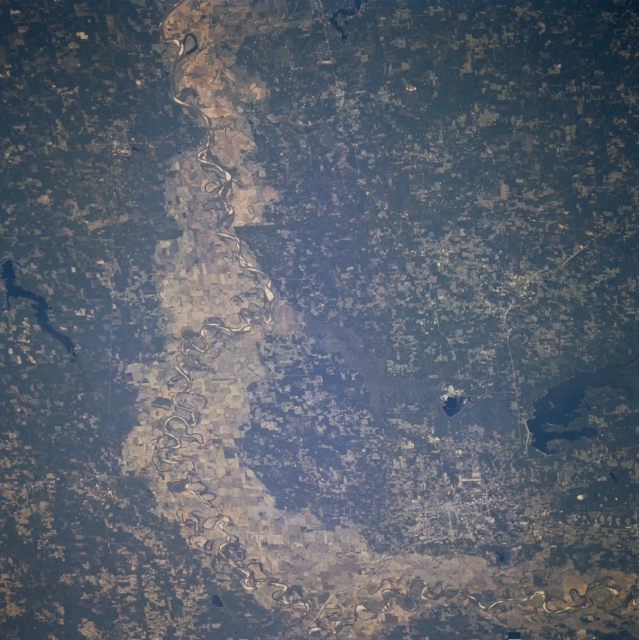 |
| STS073-726-031 Red River Valley, Northwest Louisiana, U.S.A. October 1995 The most dramatic feature of this south-looking photograph is the broad, largely cultivated floodplain of the Red River as it makes a 90-degree course change from east to south just east of Texarkana. Highly reflective sandbars, spaced randomly along the main channel of the river, allow it to be traced across the floodplain. Visible are large, dark Wright Patman Lake southwest of Texarkana and elongated Lake Erling in extreme southwestern Arkansas. Most of the landscape in this tristate area is gently rolling, verdant hills. |
| Images: | All Available Images Low-Resolution 350k |
|
| Mission: | STS073 |
|
| Roll - Frame: | 726 - 31 |
|
| Geographical Name: | USA-LOUISIANA |
|
| Features: | RED RIVER, AGRICULTURE, RES. |
|
| Center Lat x Lon: | 33.0N x 94W |
|
| Film Exposure: | N | N=Normal exposure, U=Under exposed, O=Over exposed, F=out of Focus |
| Percentage of Cloud Cover-CLDP: | 0 |
|
| Camera:: | HB |
|
| Camera Tilt: | LO | LO=Low Oblique, HO=High Oblique, NV=Near Vertical |
| Camera Focal Length: | 250 |
|
| Nadir to Photo Center Direction: | The direction from the nadir to the center point, N=North, S=South, E=East, W=West |
|
| Stereo?: | Y | Y=Yes there is an adjacent picture of the same area, N=No there isn't |
| Orbit Number: | |
|
| Date: | 1995____ | YYYYMMDD |
| Time: | GMT HHMMSS |
|
| Nadir Lat: | N |
Latitude of suborbital point of spacecraft |
| Nadir Lon: | E |
Longitude of suborbital point of spacecraft |
| Sun Azimuth: | Clockwise angle in degrees from north to the sun measured at the nadir point |
|
| Space Craft Altitude: | nautical miles |
|
| Sun Elevation: | Angle in degrees between the horizon and the sun, measured at the nadir point |
|
| Land Views: | FLOOD PLAIN, PLAIN, HILL |
|
| Water Views: | RIVER, RESERVOIR |
|
| Atmosphere Views: | |
|
| Man Made Views: | |
|
| City Views: | |
|
Photo is not associated with any sequences | ||
| NASA Home Page |
JSC Home Page |
JSC Digital Image Collection |
Earth Science & Remote Sensing |
|
This service is provided by the International Space Station program and the JSC Earth Science & Remote Sensing Unit, ARES Division, Exploration Integration Science Directorate.

|