
Geographic Region: USA-OKLAHOMA
Feature: LAKE TEXOMA, RED R.,AGR.
|
Geographic Region: USA-OKLAHOMA Feature: LAKE TEXOMA, RED R.,AGR. |
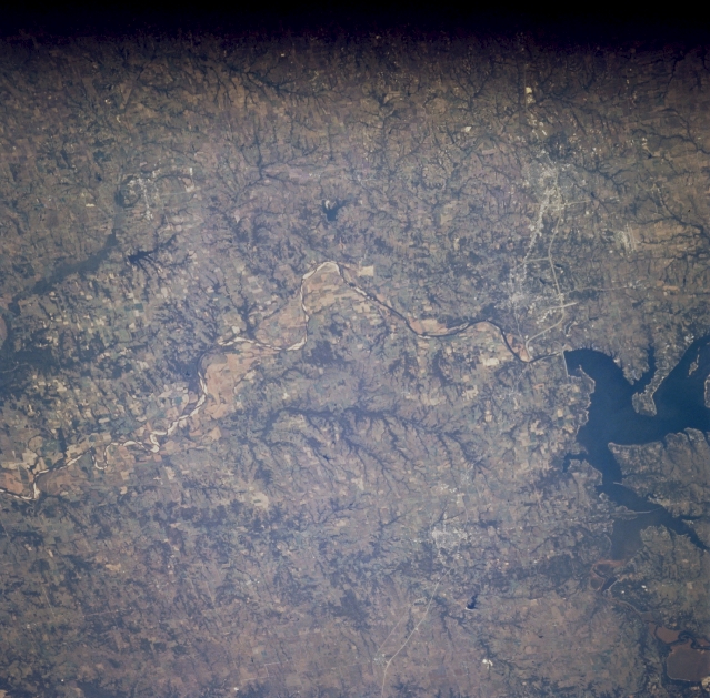 |
| STS073-726-021 Lake Texoma, Texas October 1995 Denison Dam has created Lake Texoma (part of the lake is visible as the dark feature along the right edge of the image) on the Red River. This south view of the Red River shows part of the boundary between Texas and Oklahoma. A broad floodplain of the Red River is observed east of Lake Texoma and highly reflective linear features within the main channel of the river are sandbars. U.S. Highways 75 (west) and 68 (east) are visible as they split into two separate roadways north of Sherman. These highways can then be seen merging before they cross the Red River. The faint outline of the city of Durant, OK can be viewed east of Lake Texoma. Much of the terrain on both sides of the border is flat to gently rolling prairies and is used as farmlands, either crops or cattle. The dark strip along the top of the picture is either a film processing problem or a window frame obstruction. |
| Images: | All Available Images Low-Resolution 345k |
|
| Mission: | STS073 |
|
| Roll - Frame: | 726 - 21 |
|
| Geographical Name: | USA-OKLAHOMA |
|
| Features: | LAKE TEXOMA, RED R.,AGR. |
|
| Center Lat x Lon: | 34.0N x 96.5W |
|
| Film Exposure: | N | N=Normal exposure, U=Under exposed, O=Over exposed, F=out of Focus |
| Percentage of Cloud Cover-CLDP: | 0 |
|
| Camera:: | HB |
|
| Camera Tilt: | LO | LO=Low Oblique, HO=High Oblique, NV=Near Vertical |
| Camera Focal Length: | 100 |
|
| Nadir to Photo Center Direction: | The direction from the nadir to the center point, N=North, S=South, E=East, W=West |
|
| Stereo?: | Y | Y=Yes there is an adjacent picture of the same area, N=No there isn't |
| Orbit Number: | |
|
| Date: | 1995____ | YYYYMMDD |
| Time: | GMT HHMMSS |
|
| Nadir Lat: | N |
Latitude of suborbital point of spacecraft |
| Nadir Lon: | E |
Longitude of suborbital point of spacecraft |
| Sun Azimuth: | Clockwise angle in degrees from north to the sun measured at the nadir point |
|
| Space Craft Altitude: | nautical miles |
|
| Sun Elevation: | Angle in degrees between the horizon and the sun, measured at the nadir point |
|
| Land Views: | PLAIN, VALLEY |
|
| Water Views: | RIVER, LAKE |
|
| Atmosphere Views: | |
|
| Man Made Views: | HIGHWAY |
|
| City Views: | |
|
Photo is not associated with any sequences | ||
| NASA Home Page |
JSC Home Page |
JSC Digital Image Collection |
Earth Science & Remote Sensing |
|
This service is provided by the International Space Station program and the JSC Earth Science & Remote Sensing Unit, ARES Division, Exploration Integration Science Directorate.

|