
Geographic Region: USA-COLORADO
Feature: PAN-MTS.,SNOW,RES.,AGR.
|
Geographic Region: USA-COLORADO Feature: PAN-MTS.,SNOW,RES.,AGR. |
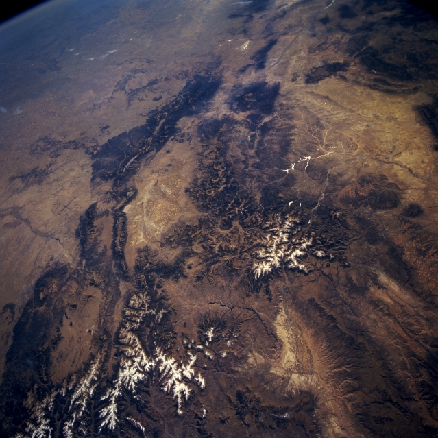 |
| STS073-722-006 Rocky Mountains, Southern Colorado and Northern New Mexico, U.S.A. October 1995 Physiographic maps or atlases will help discern the following landforms in this southeast-looking, synoptic photograph of the Rocky Mountains of southwest Colorado and north-central New Mexico. Viewing counterclockwise are the Front Range of the Rocky Mountains, Sangre de Cristo Mountains, Sawatch Range with the San Luis Valley to its south, San Juan Mountains, San Juan River Basin with sunlight reflected off the Navajo Reservoir, and the Uncompahgre Plateau and Gunnison River Valley with the Blue Mesa Reservoir to their east. Visible are snow cover on some of the higher elevations of the Rocky Mountains; the headwater areas for the Arkansas River and the Rio Grande; and a small section of the Great Plains (upper left corner). |
| Images: | All Available Images Low-Resolution 354k |
|
| Mission: | STS073 |
|
| Roll - Frame: | 722 - 6 |
|
| Geographical Name: | USA-COLORADO |
|
| Features: | PAN-MTS.,SNOW,RES.,AGR. |
|
| Center Lat x Lon: | 38.0N x 107W |
|
| Film Exposure: | N | N=Normal exposure, U=Under exposed, O=Over exposed, F=out of Focus |
| Percentage of Cloud Cover-CLDP: | 5 |
|
| Camera:: | HB |
|
| Camera Tilt: | HO | LO=Low Oblique, HO=High Oblique, NV=Near Vertical |
| Camera Focal Length: | 40 |
|
| Nadir to Photo Center Direction: | SE | The direction from the nadir to the center point, N=North, S=South, E=East, W=West |
| Stereo?: | Y | Y=Yes there is an adjacent picture of the same area, N=No there isn't |
| Orbit Number: | 4 |
|
| Date: | 19951020 | YYYYMMDD |
| Time: | 183641 | GMT HHMMSS |
| Nadir Lat: | 39.1N |
Latitude of suborbital point of spacecraft |
| Nadir Lon: | 108.1W |
Longitude of suborbital point of spacecraft |
| Sun Azimuth: | 173 | Clockwise angle in degrees from north to the sun measured at the nadir point |
| Space Craft Altitude: | 147 | nautical miles |
| Sun Elevation: | 40 | Angle in degrees between the horizon and the sun, measured at the nadir point |
| Land Views: | MOUNTAIN, VALLEY, PLAIN |
|
| Water Views: | RIVER |
|
| Atmosphere Views: | |
|
| Man Made Views: | |
|
| City Views: | |
|
Photo is not associated with any sequences | ||
| NASA Home Page |
JSC Home Page |
JSC Digital Image Collection |
Earth Science & Remote Sensing |
|
This service is provided by the International Space Station program and the JSC Earth Science & Remote Sensing Unit, ARES Division, Exploration Integration Science Directorate.

|