
Geographic Region: USA-CALIFORNIA
Feature: CHINA LAKE,RUNWAYS,AGR.
|
Geographic Region: USA-CALIFORNIA Feature: CHINA LAKE,RUNWAYS,AGR. |
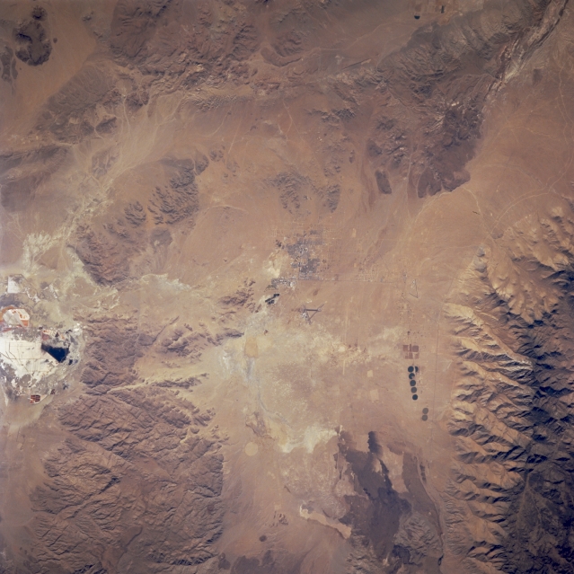 |
| STS073-711-47 China Lake, California, U.S.A. October 1995 Although most of the desert landscape in this photograph features rugged mountains (dark brown) and intermittent basins, several features indicate human activity--the street pattern for the desert town of China Lake; two triangular airfields, one north and one west; and center-pivot irrigation patterns to the northwest. To the east is highly reflective Searles Lake, made up of layers of sand, silt, and salt almost 1000 feet (305 meters) thick. The layers are mined for borax and various salts. The irregular browns to the north are exposed lava beds. |
| Images: | All Available Images Low-Resolution 316k |
|
| Mission: | STS073 |
|
| Roll - Frame: | 711 - 47 |
|
| Geographical Name: | USA-CALIFORNIA |
|
| Features: | CHINA LAKE,RUNWAYS,AGR. |
|
| Center Lat x Lon: | 35.5N x 117.5W |
|
| Film Exposure: | N | N=Normal exposure, U=Under exposed, O=Over exposed, F=out of Focus |
| Percentage of Cloud Cover-CLDP: | 0 |
|
| Camera:: | HB |
|
| Camera Tilt: | 22 | LO=Low Oblique, HO=High Oblique, NV=Near Vertical |
| Camera Focal Length: | 250 |
|
| Nadir to Photo Center Direction: | W | The direction from the nadir to the center point, N=North, S=South, E=East, W=West |
| Stereo?: | N | Y=Yes there is an adjacent picture of the same area, N=No there isn't |
| Orbit Number: | 101 |
|
| Date: | 19951026 | YYYYMMDD |
| Time: | 182258 | GMT HHMMSS |
| Nadir Lat: | 35.2N |
Latitude of suborbital point of spacecraft |
| Nadir Lon: | 116.6W |
Longitude of suborbital point of spacecraft |
| Sun Azimuth: | 158 | Clockwise angle in degrees from north to the sun measured at the nadir point |
| Space Craft Altitude: | 144 | nautical miles |
| Sun Elevation: | 40 | Angle in degrees between the horizon and the sun, measured at the nadir point |
| Land Views: | DESERT |
|
| Water Views: | PLAYA |
|
| Atmosphere Views: | |
|
| Man Made Views: | AIRPORT |
|
| City Views: | |
|
Photo is not associated with any sequences | ||
| NASA Home Page |
JSC Home Page |
JSC Digital Image Collection |
Earth Science & Remote Sensing |
|
This service is provided by the International Space Station program and the JSC Earth Science & Remote Sensing Unit, ARES Division, Exploration Integration Science Directorate.

|