
Geographic Region: USA-GEORGIA
Feature: GAINSVILLE, RES., AGR.
|
Geographic Region: USA-GEORGIA Feature: GAINSVILLE, RES., AGR. |
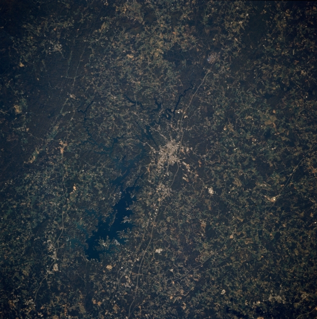 |
| STS073-708-014 Gainesville, Georgia, U.S.A. October 1995 Approximately 50 miles (80 kilometers) northeast of Atlanta are Gainesville and large Lake Sidney Lanier (near center). Discernible are two main thoroughfares that connect Gainesville and Atlanta--Interstate Highway 98S and older U. S. Highway 23--and parts of U. S. Highway 19 west of Lake Sidney Lanier. Light, linear power line rights-of-way cut through the southern fringe of dark, mountainous Chattahoochee National Forest (upper left corner). Darker features depict forested lands, and lighter areas show agricultural patterns in this gently rolling landscape of northwest Georgia. |
| Images: | All Available Images Low-Resolution 369k |
|
| Mission: | STS073 |
|
| Roll - Frame: | 708 - 14 |
|
| Geographical Name: | USA-GEORGIA |
|
| Features: | GAINSVILLE, RES., AGR. |
|
| Center Lat x Lon: | 34.5N x 84W |
|
| Film Exposure: | N | N=Normal exposure, U=Under exposed, O=Over exposed, F=out of Focus |
| Percentage of Cloud Cover-CLDP: | 0 |
|
| Camera:: | HB |
|
| Camera Tilt: | 23 | LO=Low Oblique, HO=High Oblique, NV=Near Vertical |
| Camera Focal Length: | 250 |
|
| Nadir to Photo Center Direction: | NW | The direction from the nadir to the center point, N=North, S=South, E=East, W=West |
| Stereo?: | Y | Y=Yes there is an adjacent picture of the same area, N=No there isn't |
| Orbit Number: | 84 |
|
| Date: | 19951025 | YYYYMMDD |
| Time: | 165809 | GMT HHMMSS |
| Nadir Lat: | 34.0N |
Latitude of suborbital point of spacecraft |
| Nadir Lon: | 83.1W |
Longitude of suborbital point of spacecraft |
| Sun Azimuth: | 174 | Clockwise angle in degrees from north to the sun measured at the nadir point |
| Space Craft Altitude: | 145 | nautical miles |
| Sun Elevation: | 44 | Angle in degrees between the horizon and the sun, measured at the nadir point |
| Land Views: | MOUNTAIN, FOREST |
|
| Water Views: | RESERVOIR |
|
| Atmosphere Views: | |
|
| Man Made Views: | URBAN AREA, HIGHWAY |
|
| City Views: | |
|
Photo is not associated with any sequences | ||
| NASA Home Page |
JSC Home Page |
JSC Digital Image Collection |
Earth Science & Remote Sensing |
|
This service is provided by the International Space Station program and the JSC Earth Science & Remote Sensing Unit, ARES Division, Exploration Integration Science Directorate.

|