
Geographic Region: USA-OHIO
Feature: DAYTON,RIVER,RES.,AGR.
|
Geographic Region: USA-OHIO Feature: DAYTON,RIVER,RES.,AGR. |
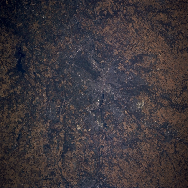 |
| STS073-707-R Dayton, Ohio October 1995 Dayton, Ohio, seen in this southwest-looking view, is the home of the inventors of the airplane, the Wright brothers. Situated on the Great Miami River where the Stillwater River joins the Great Miami, Dayton is the industrial, trade, and distribution center in a rich farming area of east central Ohio. With the location of Wright-Patterson Air Force Base northeast of the central city (airport runways are visible), Dayton is also an aviation and research center. Wright-Patterson Air Force Base was also the site of the Bosnian Peace Accords in October and November of 1995. The runways of the James M. Cox-Dayton Municipal Airport are discernible to the north (right) of the central city. To the top of the left center of the image is Caesar Creek Lake, a recreational lake on the Little Miami River. A small portion of southwest Springfield, Ohio is visible at the bottom center of the view. |
| Images: | All Available Images Low-Resolution 366k |
|
| Mission: | STS073 |
|
| Roll - Frame: | 707 - R |
|
| Geographical Name: | USA-OHIO |
|
| Features: | DAYTON,RIVER,RES.,AGR. |
|
| Center Lat x Lon: | 39.5N x 84W |
|
| Film Exposure: | N | N=Normal exposure, U=Under exposed, O=Over exposed, F=out of Focus |
| Percentage of Cloud Cover-CLDP: | 0 |
|
| Camera:: | HB |
|
| Camera Tilt: | LO | LO=Low Oblique, HO=High Oblique, NV=Near Vertical |
| Camera Focal Length: | 100 |
|
| Nadir to Photo Center Direction: | The direction from the nadir to the center point, N=North, S=South, E=East, W=West |
|
| Stereo?: | N | Y=Yes there is an adjacent picture of the same area, N=No there isn't |
| Orbit Number: | |
|
| Date: | 1995____ | YYYYMMDD |
| Time: | GMT HHMMSS |
|
| Nadir Lat: | N |
Latitude of suborbital point of spacecraft |
| Nadir Lon: | E |
Longitude of suborbital point of spacecraft |
| Sun Azimuth: | Clockwise angle in degrees from north to the sun measured at the nadir point |
|
| Space Craft Altitude: | nautical miles |
|
| Sun Elevation: | Angle in degrees between the horizon and the sun, measured at the nadir point |
|
| Land Views: | |
|
| Water Views: | RIVER, RESERVOIR |
|
| Atmosphere Views: | |
|
| Man Made Views: | URBAN AREA, AIRPORT, AGRICULTURE |
|
| City Views: | DAYTON |
|
Photo is not associated with any sequences | ||
| NASA Home Page |
JSC Home Page |
JSC Digital Image Collection |
Earth Science & Remote Sensing |
|
This service is provided by the International Space Station program and the JSC Earth Science & Remote Sensing Unit, ARES Division, Exploration Integration Science Directorate.

|