
Geographic Region: USA-CALIFORNIA
Feature: GOOSE & ABERT LAKES,PANS
|
Geographic Region: USA-CALIFORNIA Feature: GOOSE & ABERT LAKES,PANS |
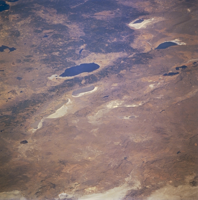 |
| STS073-707-007 Goose Lake and Warner Mountains, California, U.S.A. September 1995 This low-oblique, west-northwest-looking photograph captures Goose Lake, a salt lake approximately 30 miles (50 kilometers) long and 10 miles (16 kilometers) wide situated on a high semiarid volcanic plateau. Viewing clockwise from north of the lake are Lake Albert, located in Oregon; the north-south-trending Warner Mountains, with some peaks exceeding 8500 feet (2590 meters); the blue-gray waters of the Upper and Middle Alkali Lakes; the dry salt lakes of the Harney Basin in northwest Nevada and southeast Oregon; and Modoc National Forest. |
| Images: | All Available Images Low-Resolution 320k |
|
| Mission: | STS073 |
|
| Roll - Frame: | 707 - 7 |
|
| Geographical Name: | USA-CALIFORNIA |
|
| Features: | GOOSE & ABERT LAKES,PANS |
|
| Center Lat x Lon: | 42.0N x 120W |
|
| Film Exposure: | N | N=Normal exposure, U=Under exposed, O=Over exposed, F=out of Focus |
| Percentage of Cloud Cover-CLDP: | 0 |
|
| Camera:: | HB |
|
| Camera Tilt: | LO | LO=Low Oblique, HO=High Oblique, NV=Near Vertical |
| Camera Focal Length: | 100 |
|
| Nadir to Photo Center Direction: | NW | The direction from the nadir to the center point, N=North, S=South, E=East, W=West |
| Stereo?: | Y | Y=Yes there is an adjacent picture of the same area, N=No there isn't |
| Orbit Number: | 51 |
|
| Date: | 19951023 | YYYYMMDD |
| Time: | 165530 | GMT HHMMSS |
| Nadir Lat: | 38.0N |
Latitude of suborbital point of spacecraft |
| Nadir Lon: | 117.4W |
Longitude of suborbital point of spacecraft |
| Sun Azimuth: | 135 | Clockwise angle in degrees from north to the sun measured at the nadir point |
| Space Craft Altitude: | 145 | nautical miles |
| Sun Elevation: | 28 | Angle in degrees between the horizon and the sun, measured at the nadir point |
| Land Views: | PLATEAU, MOUNTAIN, DESERT |
|
| Water Views: | LAKE |
|
| Atmosphere Views: | |
|
| Man Made Views: | |
|
| City Views: | |
|
Photo is not associated with any sequences | ||
| NASA Home Page |
JSC Home Page |
JSC Digital Image Collection |
Earth Science & Remote Sensing |
|
This service is provided by the International Space Station program and the JSC Earth Science & Remote Sensing Unit, ARES Division, Exploration Integration Science Directorate.

|