
Geographic Region: USA-GEORGIA
Feature: SAVANNAH, RIVERS, COAST
|
Geographic Region: USA-GEORGIA Feature: SAVANNAH, RIVERS, COAST |
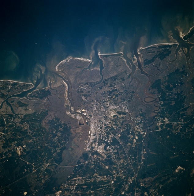 |
| STS073-706-006 Savannah, Georgia, U.S.A. October 1995 Some of the street grid patterns of Savannah are visible in this northwest-looking photograph of the east Georgia coast. Discernible are the linear runway of Hunter Army Air Field to the south and the intersecting runways of Savannah International Airport to the northwest. Light, linear north-south-oriented Interstate Highway 95 passes west of Savannah, and Interstate Highway 16 is an eastern extension of a roadway that connects Atlanta and Savannah. Apparent are darker, more elevated, wooded terrain and a gray landscape along the coast and river channel depicting low lying, swampy, vegetated areas. Sediment plumes appear at the mouths of rivers and their estuaries. Highly reflective sandy beaches jut into the Atlantic Ocean. The Savannah River and its fairly broad floodplain form the boundary between this part of east Georgia and southern South Carolina. |
| Images: | All Available Images Low-Resolution 322k |
|
| Mission: | STS073 |
|
| Roll - Frame: | 706 - 6 |
|
| Geographical Name: | USA-GEORGIA |
|
| Features: | SAVANNAH, RIVERS, COAST |
|
| Center Lat x Lon: | 32.0N x 81W |
|
| Film Exposure: | N | N=Normal exposure, U=Under exposed, O=Over exposed, F=out of Focus |
| Percentage of Cloud Cover-CLDP: | 0 |
|
| Camera:: | HB |
|
| Camera Tilt: | 30 | LO=Low Oblique, HO=High Oblique, NV=Near Vertical |
| Camera Focal Length: | 250 |
|
| Nadir to Photo Center Direction: | W | The direction from the nadir to the center point, N=North, S=South, E=East, W=West |
| Stereo?: | N | Y=Yes there is an adjacent picture of the same area, N=No there isn't |
| Orbit Number: | 36 |
|
| Date: | 19951022 | YYYYMMDD |
| Time: | 184006 | GMT HHMMSS |
| Nadir Lat: | 31.8N |
Latitude of suborbital point of spacecraft |
| Nadir Lon: | 79.6W |
Longitude of suborbital point of spacecraft |
| Sun Azimuth: | 213 | Clockwise angle in degrees from north to the sun measured at the nadir point |
| Space Craft Altitude: | 146 | nautical miles |
| Sun Elevation: | 41 | Angle in degrees between the horizon and the sun, measured at the nadir point |
| Land Views: | PLAIN, FLOOD PLAIN |
|
| Water Views: | RIVER, ESTUARY |
|
| Atmosphere Views: | |
|
| Man Made Views: | URBAN AREA, HIGHWAY, AIRPORT |
|
| City Views: | |
|
Photo is not associated with any sequences | ||
| NASA Home Page |
JSC Home Page |
JSC Digital Image Collection |
Earth Science & Remote Sensing |
|
This service is provided by the International Space Station program and the JSC Earth Science & Remote Sensing Unit, ARES Division, Exploration Integration Science Directorate.

|