
Geographic Region: USA-SOUTH CAROLINA
Feature: HILTON HEAD I.,BEAUFORT
|
Geographic Region: USA-SOUTH CAROLINA Feature: HILTON HEAD I.,BEAUFORT |
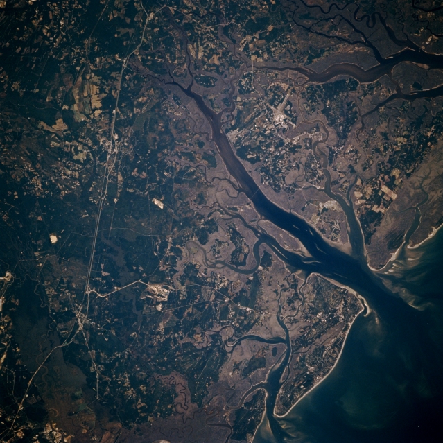 |
| STS073-706-005 Hilton Head Island, South Carolina, U.S.A. October 1995 The low-lying, swampy wetlands; estuaries; and river mouths of coastal southern South Carolina are apparent in this north-looking photograph. Two islands are of particular note--Hilton Head Island, the larger island south of the Coosawhatchie River, noted for its recreational activities (lower right corner), and Parris Island, a U.S. Marine Corps Training Center along the north shore near the mouth of the Coosawhatchie River. The reflective intersecting runways of the U.S. Marine Corps Air Base lie near the small city of Beaufort (barely discernible). Visible are several tributaries of the Salkehatchie and Combahee Rivers immediately north of the air base (upper right corner); Interstate Highway 95 and sections of U.S. Highway 17, light, linear features that extend northward; and part of the extensive, vegetated Savannah River floodplain (lower left corner). |
| Images: | All Available Images Low-Resolution 370k |
|
| Mission: | STS073 |
|
| Roll - Frame: | 706 - 5 |
|
| Geographical Name: | USA-SOUTH CAROLINA |
|
| Features: | HILTON HEAD I.,BEAUFORT |
|
| Center Lat x Lon: | 32.5N x 81W |
|
| Film Exposure: | N | N=Normal exposure, U=Under exposed, O=Over exposed, F=out of Focus |
| Percentage of Cloud Cover-CLDP: | 0 |
|
| Camera:: | HB |
|
| Camera Tilt: | 17 | LO=Low Oblique, HO=High Oblique, NV=Near Vertical |
| Camera Focal Length: | 250 |
|
| Nadir to Photo Center Direction: | NW | The direction from the nadir to the center point, N=North, S=South, E=East, W=West |
| Stereo?: | N | Y=Yes there is an adjacent picture of the same area, N=No there isn't |
| Orbit Number: | 36 |
|
| Date: | 19951022 | YYYYMMDD |
| Time: | 183955 | GMT HHMMSS |
| Nadir Lat: | 32.1N |
Latitude of suborbital point of spacecraft |
| Nadir Lon: | 80.4W |
Longitude of suborbital point of spacecraft |
| Sun Azimuth: | 211 | Clockwise angle in degrees from north to the sun measured at the nadir point |
| Space Craft Altitude: | 146 | nautical miles |
| Sun Elevation: | 41 | Angle in degrees between the horizon and the sun, measured at the nadir point |
| Land Views: | PLAIN, ISLAND |
|
| Water Views: | SWAMP, RIVER, CHANNEL |
|
| Atmosphere Views: | |
|
| Man Made Views: | HIGHWAY, AIRPORT |
|
| City Views: | |
|
Photo is not associated with any sequences | ||
| NASA Home Page |
JSC Home Page |
JSC Digital Image Collection |
Earth Science & Remote Sensing |
|
This service is provided by the International Space Station program and the JSC Earth Science & Remote Sensing Unit, ARES Division, Exploration Integration Science Directorate.

|