
Geographic Region: USA-TEXAS
Feature: AUSTIN,LAKE TRAVIS,CO R.
|
Geographic Region: USA-TEXAS Feature: AUSTIN,LAKE TRAVIS,CO R. |
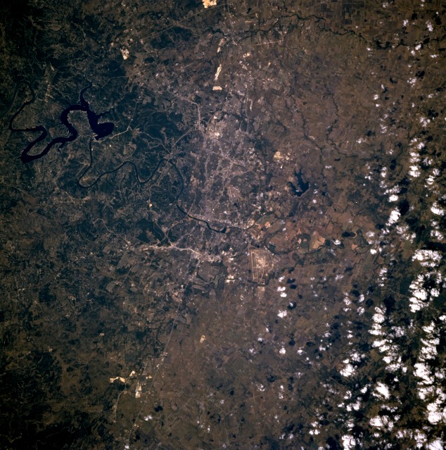 |
| STS073-706-45 Austin, Texas, U.S.A. October 1995 The highway pattern helps to identify rapidly growing Austin, the state capital (center of the photograph). Dark, serpentine Lake Travis west of Austin is part of the Colorado River that winds its way through downtown. Visible are the runway of Bergstrom Air Force Base southeast of Austin; part of Interstate Highway 35 entering Austin from the south; and the north-south-trending Balcones escarpment passing through the western part of the city. The escarpment denotes a dramatic topographic change in the landscape--gently rolling plains east of the escarpment and dissected, hilly terrain west of the escarpment. Clouds obscure agricultural lands east of Austin. |
| Images: | All Available Images Low-Resolution 171k |
|
| Mission: | STS073 |
|
| Roll - Frame: | 706 - 45 |
|
| Geographical Name: | USA-TEXAS |
|
| Features: | AUSTIN,LAKE TRAVIS,CO R. |
|
| Center Lat x Lon: | 30.5N x 97.5W |
|
| Film Exposure: | N | N=Normal exposure, U=Under exposed, O=Over exposed, F=out of Focus |
| Percentage of Cloud Cover-CLDP: | 10 |
|
| Camera:: | HB |
|
| Camera Tilt: | 23 | LO=Low Oblique, HO=High Oblique, NV=Near Vertical |
| Camera Focal Length: | 250 |
|
| Nadir to Photo Center Direction: | N | The direction from the nadir to the center point, N=North, S=South, E=East, W=West |
| Stereo?: | Y | Y=Yes there is an adjacent picture of the same area, N=No there isn't |
| Orbit Number: | 37 |
|
| Date: | 19951022 | YYYYMMDD |
| Time: | 201115 | GMT HHMMSS |
| Nadir Lat: | 29.5N |
Latitude of suborbital point of spacecraft |
| Nadir Lon: | 97.2W |
Longitude of suborbital point of spacecraft |
| Sun Azimuth: | 219 | Clockwise angle in degrees from north to the sun measured at the nadir point |
| Space Craft Altitude: | 146 | nautical miles |
| Sun Elevation: | 41 | Angle in degrees between the horizon and the sun, measured at the nadir point |
| Land Views: | HILL |
|
| Water Views: | LAKE, RIVER |
|
| Atmosphere Views: | |
|
| Man Made Views: | HIGHWAY, AIRPORT, URBAN AREA |
|
| City Views: | AUSTIN |
|
Photo is not associated with any sequences | ||
| NASA Home Page |
JSC Home Page |
JSC Digital Image Collection |
Earth Science & Remote Sensing |
|
This service is provided by the International Space Station program and the JSC Earth Science & Remote Sensing Unit, ARES Division, Exploration Integration Science Directorate.

|