
Geographic Region: USA-CALIFORNIA
Feature: OWENS LAKE, MOUNTAINS
|
Geographic Region: USA-CALIFORNIA Feature: OWENS LAKE, MOUNTAINS |
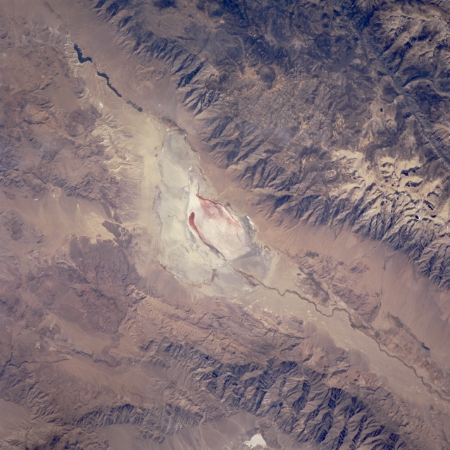 |
| STS073-706-18 Owens Lake and Owens River Valley, California, U.S.A. September 1995 The Owens River Valley, part of a fault system that forms the eastern border of the Sierra Nevada Mountains, lies between the more massive Sierra Nevada Mountains to the west and less formidable Inyo Mountain Range to the east. Owens Lake, a large dry lake receiving less than 6 inches (15 centimeters) of precipitation annually, is visible near the center of the photograph. Deprived of its feeder streams in 1913 by the Los Angeles Department of Water and Power, Owens Lake was drained within several years. In 1941 the Los Angeles Department of Water and Power began to divert water from Mono Lake to meet the needs of the growing population of Los Angeles. During the following 50 years the lake level dropped 45 feet. Rings encircling Mono Lake give testament to higher water levels. In September 1994 the California Water Resources Board, due to concerns raised by conservationists, ruled that the diversion of water from Mono Lake must be stopped. It has been mandated that the Mono Lake level should be allowed to rise to 6,391 feet, a level that some experts estimate will take 20 years to attain. The dark, linear feature in the upper right corner is part of the Kern River Valley. Mount Whitney, the highest peak [14 491 feet (4417 meters)] within the 48 contiguous states, lies northwest of Owens Lake in the Sierra Nevada Mountains. |
| Images: | All Available Images Low-Resolution 342k |
|
| Mission: | STS073 |
|
| Roll - Frame: | 706 - 18 |
|
| Geographical Name: | USA-CALIFORNIA |
|
| Features: | OWENS LAKE, MOUNTAINS |
|
| Center Lat x Lon: | 36.5N x 114W |
|
| Film Exposure: | N | N=Normal exposure, U=Under exposed, O=Over exposed, F=out of Focus |
| Percentage of Cloud Cover-CLDP: | 0 |
|
| Camera:: | HB |
|
| Camera Tilt: | 46 | LO=Low Oblique, HO=High Oblique, NV=Near Vertical |
| Camera Focal Length: | 250 |
|
| Nadir to Photo Center Direction: | E | The direction from the nadir to the center point, N=North, S=South, E=East, W=West |
| Stereo?: | Y | Y=Yes there is an adjacent picture of the same area, N=No there isn't |
| Orbit Number: | 37 |
|
| Date: | 19951022 | YYYYMMDD |
| Time: | 200639 | GMT HHMMSS |
| Nadir Lat: | 36.3N |
Latitude of suborbital point of spacecraft |
| Nadir Lon: | 116.5W |
Longitude of suborbital point of spacecraft |
| Sun Azimuth: | 192 | Clockwise angle in degrees from north to the sun measured at the nadir point |
| Space Craft Altitude: | 146 | nautical miles |
| Sun Elevation: | 42 | Angle in degrees between the horizon and the sun, measured at the nadir point |
| Land Views: | MOUNTAIN, FAULT, RIFT |
|
| Water Views: | PLAYA |
|
| Atmosphere Views: | |
|
| Man Made Views: | |
|
| City Views: | |
|
Photo is not associated with any sequences | ||
| NASA Home Page |
JSC Home Page |
JSC Digital Image Collection |
Earth Science & Remote Sensing |
|
This service is provided by the International Space Station program and the JSC Earth Science & Remote Sensing Unit, ARES Division, Exploration Integration Science Directorate.

|