
Geographic Region: USA-CALIFORNIA
Feature: SAN JOSE,LIVERMORE,MTS.
|
Geographic Region: USA-CALIFORNIA Feature: SAN JOSE,LIVERMORE,MTS. |
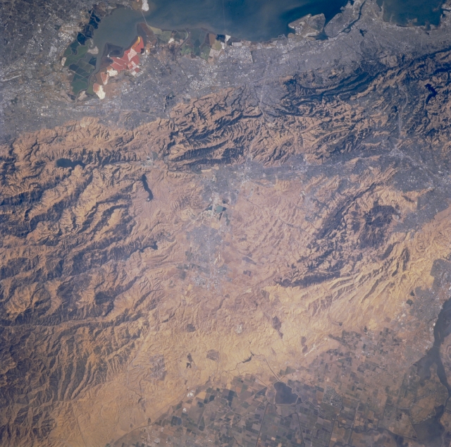 |
| STS073-706-016 Livermore, California, U.S.A. October 1995 This photograph features the easily recognizable southern San Francisco Bay and the multicolored salt ponds along the south and southeast shorelines. To the east is the southern Diablo Range. None of the infrastructure of Livermore is discernible in the center of the photograph. Several ridges and hills separate the densely populated San Francisco Bay Area from the less populous valley to the east. Some cultivated field patterns are discernible in the lower right corner. |
| Images: | All Available Images Low-Resolution 370k |
|
| Mission: | STS073 |
|
| Roll - Frame: | 706 - 16 |
|
| Geographical Name: | USA-CALIFORNIA |
|
| Features: | SAN JOSE,LIVERMORE,MTS. |
|
| Center Lat x Lon: | 37.5N x 121.5W |
|
| Film Exposure: | N | N=Normal exposure, U=Under exposed, O=Over exposed, F=out of Focus |
| Percentage of Cloud Cover-CLDP: | 0 |
|
| Camera:: | HB |
|
| Camera Tilt: | 23 | LO=Low Oblique, HO=High Oblique, NV=Near Vertical |
| Camera Focal Length: | 250 |
|
| Nadir to Photo Center Direction: | W | The direction from the nadir to the center point, N=North, S=South, E=East, W=West |
| Stereo?: | Y | Y=Yes there is an adjacent picture of the same area, N=No there isn't |
| Orbit Number: | 37 |
|
| Date: | 19951022 | YYYYMMDD |
| Time: | 200546 | GMT HHMMSS |
| Nadir Lat: | 37.2N |
Latitude of suborbital point of spacecraft |
| Nadir Lon: | 120.5W |
Longitude of suborbital point of spacecraft |
| Sun Azimuth: | 186 | Clockwise angle in degrees from north to the sun measured at the nadir point |
| Space Craft Altitude: | 146 | nautical miles |
| Sun Elevation: | 42 | Angle in degrees between the horizon and the sun, measured at the nadir point |
| Land Views: | MOUNTAIN, FAULT |
|
| Water Views: | |
|
| Atmosphere Views: | |
|
| Man Made Views: | URBAN AREA |
|
| City Views: | OAKLAND |
|
Photo is not associated with any sequences | ||
| NASA Home Page |
JSC Home Page |
JSC Digital Image Collection |
Earth Science & Remote Sensing |
|
This service is provided by the International Space Station program and the JSC Earth Science & Remote Sensing Unit, ARES Division, Exploration Integration Science Directorate.

|