
Geographic Region: USA-NEVADA
Feature: PYRAMID L., CARSON SINK
|
Geographic Region: USA-NEVADA Feature: PYRAMID L., CARSON SINK |
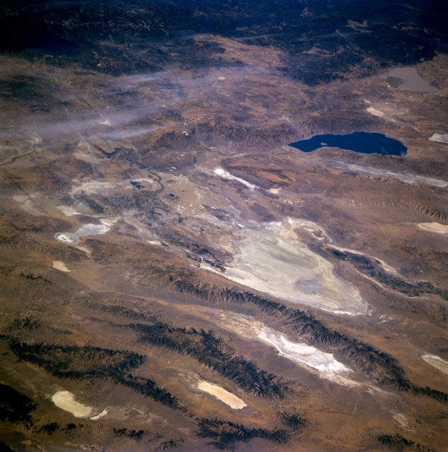 |
| STS073-704-084 Carson Sink, Nevada, U.S.A. October 1995 Large, highly reflective Carson Sink, near the center of this low-oblique, west-looking photograph, is a dry lakebed measuring approximately 20 miles (32 kilometers) in diameter. A part of the larger Carson Desert, Carson Sink is very flat, with an elevation that varies less than 10 feet in its central part. Its salt-encrusted surface is devoid of vegetation except for small areas of saw grass at the mouths of the Carson River, which enters the sink from the southwest, and the Humboldt River, which enters the sink from the north. Because both of these rivers flow only intermittently, with any available water being diverted for agriculture farther upstream, little water actually reaches Carson Sink. A series of northeast-southwest-oriented mountain ranges east of Carson Sink--the Stillwater Range, Clan Alpine Mountains, and Desatoya Mountains--are separated by valleys that contain smaller, highly reflective dry lakes. Large Pyramid Lake and Lake Tahoe appear west and southwest, respectively, of Carson Sink. |
| Images: | All Available Images Low-Resolution 342k |
|
| Mission: | STS073 |
|
| Roll - Frame: | 704 - 84 |
|
| Geographical Name: | USA-NEVADA |
|
| Features: | PYRAMID L., CARSON SINK |
|
| Center Lat x Lon: | 39.5N x 119W |
|
| Film Exposure: | N | N=Normal exposure, U=Under exposed, O=Over exposed, F=out of Focus |
| Percentage of Cloud Cover-CLDP: | 5 |
|
| Camera:: | HB |
|
| Camera Tilt: | LO | LO=Low Oblique, HO=High Oblique, NV=Near Vertical |
| Camera Focal Length: | 250 |
|
| Nadir to Photo Center Direction: | W | The direction from the nadir to the center point, N=North, S=South, E=East, W=West |
| Stereo?: | N | Y=Yes there is an adjacent picture of the same area, N=No there isn't |
| Orbit Number: | 36 |
|
| Date: | 19951022 | YYYYMMDD |
| Time: | 183235 | GMT HHMMSS |
| Nadir Lat: | 39.1N |
Latitude of suborbital point of spacecraft |
| Nadir Lon: | 112.9W |
Longitude of suborbital point of spacecraft |
| Sun Azimuth: | 166 | Clockwise angle in degrees from north to the sun measured at the nadir point |
| Space Craft Altitude: | 146 | nautical miles |
| Sun Elevation: | 39 | Angle in degrees between the horizon and the sun, measured at the nadir point |
| Land Views: | DESERT, MOUNTAIN |
|
| Water Views: | LAKE, PLAYA |
|
| Atmosphere Views: | |
|
| Man Made Views: | |
|
| City Views: | |
|
Photo is not associated with any sequences | ||
| NASA Home Page |
JSC Home Page |
JSC Digital Image Collection |
Earth Science & Remote Sensing |
|
This service is provided by the International Space Station program and the JSC Earth Science & Remote Sensing Unit, ARES Division, Exploration Integration Science Directorate.

|